Mill Street Danville, Pennsylvania
A Postcard Tour - Block by Block Through The Decades
Dates To Keep In Mind, For Dating Photos:
[Keeping in mind that photo postcards even in 1900 sometimes were retouched, removing details such as poles and trolley tracks from the images]
Trolley 1903-1926
Canal 1831- 1904
Streets Paved With Brick 1904
Street Lamps 1923- ?
===================
The Intersection Of Mill & Bloom Streets
====================
Although technically located on Bloom Street, the Montgomery House is a landmark, at the base of Mill Street where it intersects with Bloom Street, that helps to give perspective when viewing the photos of Mill Street. It can often be spotted at the back of the photo, assuring you that the photographer is looking north on Mill.
The Montgomery House, built in 1792, sits at the intersection of Bloom and Mill streets. It is the oldest building in Danville. Montgomery originally built a log cabin, building the stone portion of his new home in 1792. The framed wooden section was added sometime prior to 1857. William Montgomery's descendents lived in the home until 1939, when Miss Helen Russell passed away. The house, along with the Boyd House, were purchased by the Danville Elks, who deeded the Montgomery House to the County, and the county deeded it to the Historical Society. The Montgomery House Museum was opened in 1941.
Looking North.
Montgomery House visible, trolley tracks
Union Hotel Sign visible on the left
J.H. Cole's on right
Odd fellows Decorations 1909
I could be wrong about the location of this one - but I think this is near the Bloom intersection, west side of the street.
The building on the left is a Hotel. In 1923 the Sanborn fire map shows the Union Hotel here.
In the middle there is text on the building behind the buntings that I wish I could read.
On the right is Vincent's Milk Depot.
Looking North From Mill Street, looking right at the Montgomery Home.
Look up in the top right, in the branches of the tree you can see the First National Bank Sign.
Note the tree right in the middle of the intersection, decorated in Christmas lights. A traffic signal can be made out behind the tree.
"The Montgomery Building was erected in 1841 and added to in 1845 by Alexander Montgomery, son of Gen. Wm Montgomery. It sat on the corner of Bloom and Mill Streets, where the Fulton Bank now stands. [across from the Montgomery Home] It was once occupied by various stores such as MC Grier’s drug store, AF Russell Dry Goods and the office of the Danville Democrat newspaper. In April 1848 the entire building was destroyed by a fire. Mr. Montgomery rebuilt the building the same year and it became one the prominent buildings in the center of Danville’s business area" - Danville, Montour County by Brower
Photo of the Bank at Mill and Bloom, in the old Montgomery Building. Built in 1848, this building was razed in 1923.
The First National Bank of Danville was chartered on January 25, 1864, in the fourth year of the Civil War, under the National Banking act of 1863 and was given Charter No. 325. The Bank opened in the old Montgomery Building which stood on the southeast corner of Mill and Bloom Streets, the site of the present FNB Bank. In 1887 the directors purchased the building in which it had been housed since its beginning and made extensive improvements. The Montgomery building was razed in 1923 and replaced by the structure used by FNB today. Alexander Montgomery built the first portion of the Montgomery Building in 1841 and the balance in 1845. This entire building was destroyed by fire in 1848, Montgomery contracted to rebuild on the site immediately but passed away before completion. The executors of his will carried through with the contract and it was completed in the same year.
Bank, drugstore, grocery, millinery, Dry Goods, Saloon, Hardware
Sanborn Fire Map, 1930
Intersection of Bloom and Mill
The blue building beside the Elks is the Montgomery House
Across the street is the first national Bank, and a drugstore.
At the intersection in 1923, showing the Union Hotel, and another Baldy Building along Bloom/Northumberland St.
=====================
Lower Mulberry To The Canal, on Mill Street
====================
1908
Public Telephone Sign on Left
Railroad Tracks crossing Mill Street
Is that a policeman beside the tracks at the intersection?
View From Bloom St looking south - same view as above, decades later.
On the right is American Restaurant, and Straub Pharmacy with the awning.
Notice that the three globe light on the left does not match any of the others down the street.
[That light is in front of the First National Bank, I believe]
Danville's held a carnival, and dances, to raise money for their street lights
Looking west - from Bloom, further down? Trolley Tracks visible.
Montgomery House is located straight ahead at the back of this photo. Other visible signs included:
Terrapin & Turtle on left, Tooley’s Cash Store, Local Long Distance Telephone Penna. Tel. Co., C. W. Ruckle Jewelers (giant pocket watch), Welliver’s Hardware, Ice Cream, 5 & 10 Store
Notice in the above postcard, the Tooleys sign reads Fooleys. That's not the only edit, the original photo included poles that were removed. See the comparison here.
More about Tooley's
Mummers Parade on Mill Street 1910
Tooley's on the right. That was 318 in 1910, the 500 block today
Murrays is again visible, on the northwest side of the railroad tracks
Today that building is 583 Mill Street
B.F. Cohe's Clothing Store was listed at 287-289 Mill Street
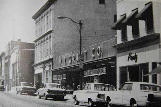
W.T Grant Building can be seen - lowest building on right
the Masonic Temple can be seen 3/4 of the way up the street on the right.
J.W. Lore Jeweler on Right
Note the white triangular over hang near the back of the photo - that is the sign for Tooley's Grocery
This is current day 558 Mill Street.
Looking at the photo above this one, I think [and I could be very wrong!] that this is the building with the flag in the above photo.
In the above photo, look at where the railroad tracks are - that gap near the left. Then two buildings, and then the white building roofline drops down a bit... it's a possibility. I'll wait for someone who knows more to correct me. :-)
Eckman's on the right
The sign to the left and the awning appear in the two photos preceding this one.
Montgomery House Visible in the back of the photo
In 1955, Gem was located at 307-315 Mill Street. Today that would be 564 Mill Street, I think. In 1967, Gem Furniture Company signed an agreement to purchase a parcel of land in the urban renewal area, for a new building to be used for storage, merchandising and display.
1936 Flood
Note the flat front on the Herman's Auto Supply Building
Now look at this street view in 2023:
If that is the correct building, today what was once Hermans is now 519 Mill Street1972 flood. Looking North
An advertisement for J. Doster's Sons puts the building at 298-300 Mill street. It looks like this may be the same building the Old Forge is in today - at 529 Mill Street?
Looking South
F.M. Kirby Store [prequel to Newberys] on the East side of the street
These distinctive windows appear to still be on the building that is today 514 Mill Street.
Newman's store, on the right, was located at 226 Mill Street, Danville In 1899 when Newman came to Danville, that location was occupied by Peter's Oyster House, and Best's Millinery Store. [400 block today. Premier Clothing building maybe?]
Read more about Newman's:
The first Grant store opened in Danville in 1928 at 280 Mill street.
Because of the changes in addresses on Mill street over the years, I am just not certain which building that was.
The new W.T. Grant store opened in 1954 at 255-265 Mill Street - today the address for that same building is 491 Mill Street.
W.T. Grant Co New Building in 1954
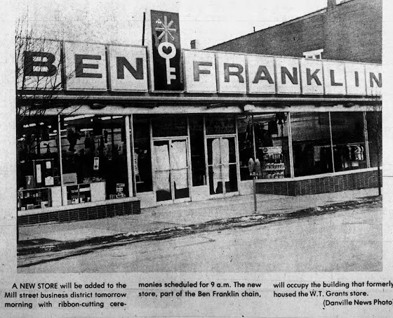
[Later Beiters, Then Ben Franklin]
The Masonic Building can be seen to the left
The ribbon cutting for the new Ben Franklin store in Danville was held on February 10th 1977. The building formerly housed the W.T. Grant store.
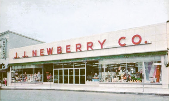
Across the street from Ben Franklin/Beiters was the J.J. Newberry store, today the Salvation Army store at 486 Mill Street.
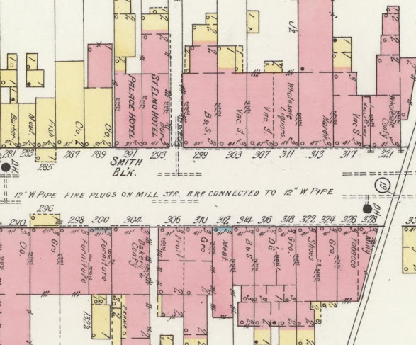
1913 Sanborn Map
Mill Street from the Bloom intersection south
On the west side is a wholesale confectionary, Hardware, Wholesale Liquors, Boots & Shoes St Elmo Hotel, Palace Hotel, Clothing, Fish, Meat, Barber
Across the street, to the east -
Millinary, Tobaco, Grocery, shoes, grocery, dry goods, boot and shoe, meat, grocery, fruit, bakery & confectionary, furniture, grocery,
From Lower Mulberry To The Canal, Sanborn Map 1930
There was an ice house behind 279
281-83 Auto Sales
291 was labeled the Smith Block
There was a baske house with large oven in the rear of 304,
================
The North Branch Canal
And the Bridge, where It Crossed Mill Street
=================
Looking across Mill Street, from the Canal
A bridge crossed over the canal, connecting Mill Street.
Read more about the North Branch Of the Canal here:
Mill street, with a mess near the Canal Bridge.
Was this possibly when the canal bridge collapsed in 1860?
Or when the canal was being filled in, abt 1904?
In 1860 a tightrope walker came to Danville, and so many came to watch that the canal bridge collapsed. Read more about that here:
Canal bridge on Mill Street
Racket's store shown on the right
Sign at this location today
"In 1826 Daniel Montgomery, for whom the town of Danville was named, was elected president of the Board of Canal Commissioners. The North Branch Canal was surveyed in 1826-27 with construction of the canal between Northumberland and Nanticoke beginning in 1828. The first water was turned in during 1832 opening up a new transportation corridor.
At Danville the canal veered away from its normal place along the river to the center of town close to where the Montgomery family had mills. At one time Mill Street merchants advertised their business as north or south of the canal. Both cargo and packet boats, which had sleeping and dining accommodations traveled the canal attracting local residents and visitors to the dock with the sounding of a conch horn announcing their arrival. In 1849 more than 5,000 people greeted the troops returning home in packet boats from the War with Mexico.
The use of anthracite coal in the iron furnaces in Montour County and the rolling of the first T Rail for building railroads at the Montour Iron Works on October 8, 1845, contributed significantly to the success of the North Branch Canal. Thousands of tons of coal were shipped from the Wyoming coalfields to produce the rails, which in turn were shipped to markets by canal boats pulled by mules at 4 miles per hour. Ironically, as railroads were built, they became the preferred method of transportation, leading to the demise of the canal system."
1913 Sanborn Fire Map Showing the Canal now dry
==============
From The Canal To Mahoning Street
Masonic Temple, Bank
=======================
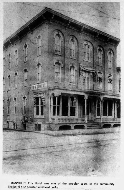
The City Hotel, built in 1872
Also the location of the White Swan Hotel, at some point.
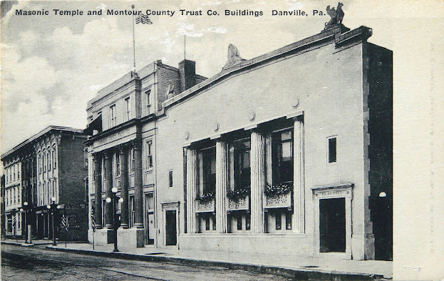
In the 1920s, The The Montour Trust Company added the massive concrete facade to the building.
The city hotel, which later became the Montur Trust Company. To the right is the building that was torn down to make way for the new Masonic Building. Trolley hauling a snow wagon on the street.
239 Mill Street is the Municipal Building today, housed in the former Masonic Building. Before the Masonic Building was erected, this fountain stood in that area.
Was this possibly the Women's Christian Temperance Union Fountain? The Danville chapter installed their fountain in July of 1900. The W.T.C.U. installed town fountains, to give travelers a place to get a drink without needing to go into a tavern for alcohol - often the only option previously available.
Read more about the W.C.T.U. Fountain Initiative here:
Montour Trust Company
I'm unsure how edited this photo is. Notice the lights are different than in the photo above. The building to the right is also missing, so either this was taken when that building was torn down, before the new Masonic building was constructed, or the other building was simply edited out of this photo.
Mill St From The Canal, To Penn Street
on the 1930 Sanborn Fire Map
[note that the blue creek is not the canal. The canal ran in the empty white space in the middle of this section of the map]
233 Bank
235-237 Masonic Temple
209-253 Lodge 3rd, Borough Offices 2nd, Plumber & Printing
Across the street - 250: Pool Room, 268: Photos
Jail located behind the borough offices
==================
Mill Street From Penn To Mahoning
The Opera House, I.O.O.F. Hall,
==================
The Opera House on the right was later the Victoria Theater
410 Mill Street [ Today the Post Office]
Looking North From The Opera House, 1909
Just to the south of the Opera House, on the right, you can see part of the Elks Building and Post Office
Looking North. On the right is The Victoria Theater/Opera House, Today the Post Office
In 1949, Gem Furniture was located at 401 Mill Street, in the old Opera House Building. In 1897, P.C. Murray and Sons operated a Department store at that location.
The new post office, where the Opera House/Victoria Theater previously stood.
Sign for an Ice Cream and Candy Shop
Jouvaurd & Lavigne Recreation Building in 1920
[the 1930 Sanborn Map lists this as the IOOF Hall, the 1923 map shows it as a club house]
201 Mill Street (located directly across from the old Opera House, or today, across from the Post Office)
Mr. J.F. Lavigne moved with his family from New York to Danville in 1914 after he and Lucien Jouvaurd purchased the F.Q. Hartman Silk Mills. Lavigne established a recreation center in 1919 at the corner of West Mahoning and Mill Streets to provide a healthy environment for the female workers in his mills. There, the young ladies were taught cooking and etiquette and had the use of a reading room and a swimming pool in the basement. Lavigne also established Camp Lavigne on Cole’s Creek above Benton as a Boy Scout Camp. He also served as the first president of the local Columbia-Montour Council of the Boy Scouts of America.
1913 Sanborn Map
Mill Street From Canal to Mahoning
East Side: Grocery, News & Books, Commonwealth Hotel, Barber/Photos, offices, Cobbler, Barber, Dry Goods and lodge on the 3rd floor, And the Opera House which included, Business College, Teas & Crockery, Drugs and Telephone exchange.
On the west side was Jewelry, Millinery, City Hotel, Gas & Electric Supplies, Insurance Office, Telegraph Office, Barber, Millinery, Express, Meat,
Penn To Mahoning 1930 Sanborn Fire Map
201-205 IOOF Hall
200-210 - Victoria Theater [Opera House] including Business College & Telephone Exchange, 212 Lodge
================
Mill Street From
Market To Mahoning
The Baldy, The Luna, Heddens
=================
Heddens Mansion House Restaurant
This building was lost in a fire November 1911.
The article about the 1911 fire lists the businesses on that block at the time.
Standing at the Opera House Looking South
Heddens Restaurant, The Luna Theater, M.S. Schramm Hardware
Looking North
Luna & Heddens on left, on the right the Opera House [Victoria Theater] can be seen on down on the right.
M.S. Schramm Hardware, The Luna Theater, Heddens Restaurant
The Elks Building, and Post Office, West Side Of the road
Keystone Building - Formerly the Post Office and Elks Building
The Luna later became the Ritz theater. The Ritz burned down in 1936 (the Opera House/Victoria Theater nearby was torn down a year later).
The Capitol theater was built at the location of the former Luna/Ritz by July of 1936.
2023 street view
The large brick building on the left is the Capital theater that replaced the Luna. The building on the far right is where Heddens was located.
Looking North
1912 - Showing the Baldy on the right, and the Luna & Heddens on the left.
(I'd love to see more of that Baldy Mural!)
118 – 120 Mill Street,
Built in 1870 by Peter Baldy, as a home, and then converted into a hotel by William Williams in 1891.
The Baldy
This is looking north - the Baldy is on the right, and the arched architecture of the Luna can be made out on the left.
Same view, during Christmas. The Baldy is the distinctive building on the right.
On Feb 19, 1850 the Bank of Danville opened for business. Danville's first bank was on the corner of Mill and West Markets Streets.
In the 1904 Sholes Directory for Danville, there were 3 banks listed, all on Mill street:
Peoples Bank 200 Mill Street
First National Bank 354 Mill Street
Danville National Bank Mill & Corner of Market
Gosh's Drug Store was located at 108 Mill St in 1897, advertising hot water bottles at 75 cents, and "no mistakes with our new numbering machine." In 1949, Cain's Pharmacy was in that location.
In 1913 the Sanborn Fire Map Shows, in this section:
Bank, Office, D.G. & Gro, Hardware, Luna Motion pictures, restaurant [tobacco & Billiards] and on the opposite side of the street:
Dentist, Drugs, S, Tobacco, Barber, Baldy House [with bar], Express, Wallpaper, confectionary, Drugs, P.O & Elks Lodge & Club
Mill Street from Market Street To Montour Street
The Bank is shown at 101, Luna Motion Pictures from 119-131, and an office at 129
Across the street we see an office at 100, Printing BSF at 114-16, a Candy Warehouse behind 122-124, Cleanign and Peessing at 128, and the Post Office and Elks Lodge at 133-134 and 150-152
For this section of Mill from Market to Mahoning, the 1904 directory lists:
Post Office, Hotel Baldy, Montour Coal & Iron Co, Standard Electric Light & Standard Gas Co, Boston store, J.D. Gosh & Co, Danville National Bank, among others
===================
From Market Street To The River
The Courthouse, Montour House, & Riverview Hotel
=========================
The Heddens House Hotel was located on Mill Street next to the Montour County Courthouse. Operated by James and Margaret Heddens, rooms cost between $1 & $1.50 in 1900, about $56 in 2024. In a an advertisement in the 1911 Danville City Directory, the Heddens House was called "The hotel that is just like home." The ad also noted the hotel had its own stable, and featured the latest improvements, including steam heat and electric lights.
In addition to the Montour hotel across from the courthouse, there are 3 additional hotels [including Riverview] beside the courthouse in 1923.
The Courthouse
Read more about the Montour County Independence, here:
Montour County Courthouse, 253 Mill Street [address in 2024]
When Columbia County was established in 1813, Danville was the county seat. Thirty two years later, in 1845, the county seat was moved to Bloomsburg.
According to the Bloomsburg newspapers, who were undoubtedly biased, this was because Danville could not raise the funds to improve their buildings. The buildings were old, not fire proof, and in disrepair.
"Since 1837, the buildings have grown more dilapidate and unfit for use. There are no fire proofs to secure public documents from destruction. The court house is a brick erection nearly 40 years old. The sheriff's house is unfit for use and the Jail is indifferent as regards to arrangements for safety and comfort."
The result was a long fight between Bloomsburg and Danville, resulting in a very controversial political move that created a new county, Montour.
Read more about that here:
Tydol sign visible across from the courthouse.
============================
Standing just south of the courthouse, looking north. The large building is the Montour House.
Standing at the Montour Hotel, looking north east.
Montour Hotel, Danville Pa
The Montour was located directly across from the court house, on Mill Street.
Read more here:
In 1965, the Danville National Bank purchased the Montour House property and turned it into a parking lot. Demolition began on May 26th, 1965.
Looking North, up Mill Street, from the river.
Riverview Hotel on the left, Note the gabled roof line. In later photos, the hotel is a full 3 stories tall with a flat roofline.
On the 1885 Sanborn fire map, this building is labeled the Revere Hotel, and the building just north of it is labeled the Union Hall Hotel.
Riverview Hotel, with the top of the courthouse visible in the background.
1920s - the trolley tracks are still visible, and the street lights have been installed.
Riverview Hotel
Opened in 1812 by John Gulick, as the Farmers Hotel.
Names the hotel at this location operated under include:
Farmers Hotel
Pennsylvania House
Revere House
Riverview
In 1998 Penndot purchased the building and demolished it to widen the approach to Mill Street. It now is a parking lot owned by the County.
1885
1930 Sanborn Fire Map
Showing from the North Branch of the Susquehanna, to Market Street.
Remember, the old iron bridge met up at Mill street. When the new cement bridge was constructed, it was to the east, not at the same location as the bridge shown on this map.
Showing the old bridge, and the new
The old metal bridge lined up with Mill Street.
The 1904 Sholes Directory lists for this section:
Court House, Montour House, Heddens House, Gillaspy House, among others
=============================
NOT PLACED
Jacob Candy was advertised at 126 & 304 Mill Street
2?6 over the door - maybe 236?
A.G. Harris Post Cards
240 Mill Street?
Looking at the buildings today, this might possibly be 438 Mill Street today? Just a guess though. There's also some resemblance to the Opera Building.
=============================
Directories & Store Listings
=============================
Edward Francis Fallon operated an Ice cream Parlor at 327 mill street starting in 1918.
Titel’s Hotel, Elizabeth Titel, Proprietor on the left, 339 Mill Street
J. H. Cole Hardware on the right, 336 Mill Street.
In 1899 Sam J. Welliver Hardware Store was located at 307 Mill Street
In 1949, Keefer's Department store was located at 298-300 Mill Street. In 1897, J. Doster's Son's was at that location.
1936 Businesses
=======================


.jpg)


.jpg)





.jpg)







Hello! I live at 450 Mill st. I believe this used to be 234 Mill St, is the building I live in currently the old Cole’s building??
ReplyDelete