There are 24 named waterfalls on this 7 mile trail. Twenty Four! It's one of the most beautiful areas, anywhere, and it's practically in our back yard - just 30 minutes east of Hughesville. Pack some snacks, and a water bottle, and make a day out of it - it's a truly incredible hike - and it's free.
You can skip the "tail" (3 waterfalls) and just do the upper loop - that makes this hike just over 3 miles. Adams Falls, one of the most beautiful in the park, can be seen just a short walk from the lower parking area.
Quick Links:
- The DCNR Site For Ricketts Glen
- Hiking From Adams Falls To Waters Meet
- Adams Falls - A very short walk from the parking area
- Kayaking Lake Jean (At Ricketts Glen)
A Note About Winter Hiking -
The Falls Trail closes for "the ice season" which usually is sometime in November to sometime in mid-April. (The area is typically much colder than our surrounding towns) The only ones permitted on the trail at that time are those who are experienced hikers and are properly equipped with ice crampons, ice ax, and rope. Those hiking with proper equipment must sign in and out at the park office. Check out Valley To Summit for a Guided Ice Hike
We've been hiking this trail for 20 years. I've hiked to Ganoga while pregnant with the twins, and we hiked the 3 mile loop when the twins were 6 months old, and in packs on our backs. Our dogs love this trail. Now I'm not saying it's an easy hike - it's pretty steep uphill in places (but almost all of those places have steps now, unlike when we were kids. So steep, but steep steps, not a steep scramble) But this is definitely a hike the average person can tackle without much trouble.
Note - I have some friends with health issues that make walking uphill very difficult. My suggestion in those cases - take two cars. Park one at the top and one at the bottom. Walk down one side of the loop, drive back to the top, walk down the other side of the loop. It still will not be an easy, flat, walk, but you will avoid most of the steep uphill climbs if you do it that way. The trail is more of a Q than a true loop, so if you do it that way, you will walk the "tail" of the Q twice - but it's a pretty section with a few falls.
For this trip, we started at the "You Are Here" at the top left of this sign, walking down past Ganoga (the largest fall here), to waters meet. from there we hiked down to see the three waterfalls on the "stem", then went back up to Waters meet, and continued around the other side of the loop. We really took our time, stopping at every fall for pics, often to get close, or at least have our feet, right in the water. We also stopped for snacks twice, and just to sit and watch the water. It took us 4 hours.
They have made a LOT of improvements to the trail, and last year to the parking area - there is now a fully paved lot, with bus parking! Along with new bathrooms, and a new pavillion:
I've hiked this in flip flops pretty often.. but I'm not exactly normal, and it's not something I'd recommend to others. I prefer to hike barefoot as much as possible. There are some slippery parts, and some steep parts, but they have made this trail SO nice, most of it is really smooth, or has nicely defined steps. It's a big improvement over 20 years ago.
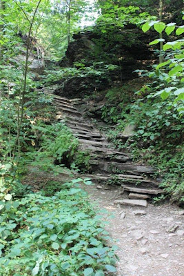
Some of the trail:
Steps..
Nice flat rocks
Don't let the map confuse you - this trail is VERY clearly marked. Dan was using the map to identify which waterfalls were next.
That is the trail there on the right.. it's a little slick, but not too difficult at all.
Some of the steps are steep, there are a lot of steep climbs here..
A few of the waterfalls here:
=================================
Places To Hike


No comments:
Post a Comment
I'll read the comments and approve them to post as soon as I can! Thanks for stopping by!