
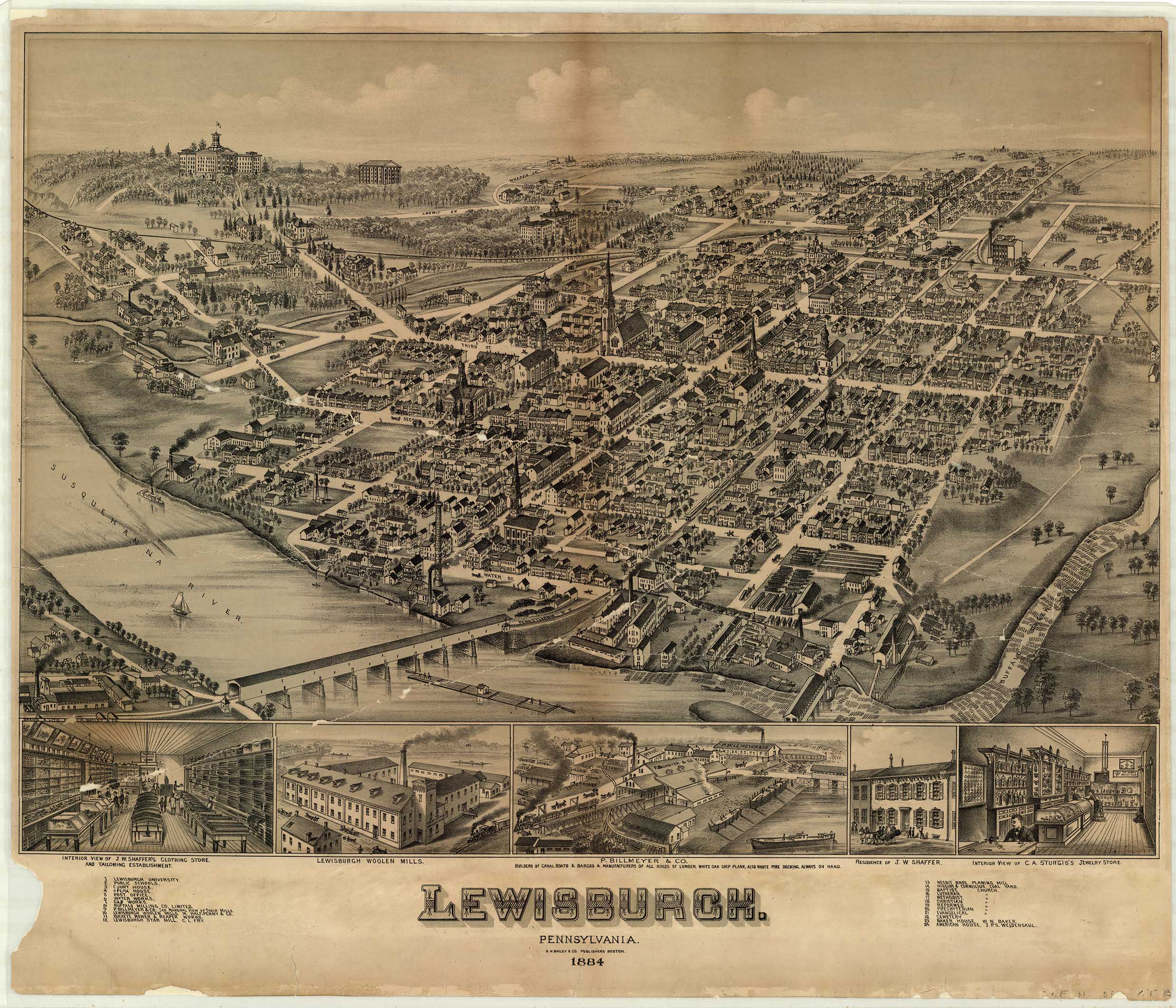
Thomas Mortimer Fowler sketched over 400 maps in his life time, more than 200 of locations in Pennsylvania. His maps were a marvel, complete with three-dimensional renderings of every building, bridge and horse-drawn wagon in town. Many of our local towns, including Milton, Watsontown, and Mifflinburg, were sketched by Fowler.
About The Artist
T. M. Fowler, as he signs his maps, was born in Lowell, Mass., in 1842. At the age of 15, he left home against his father’s wishes to pursue a career in art. Soon destitute, he found himself in Buffalo, N.Y., at the start of the Civil War. He was finally admitted to the Union Army in 1861. At the Second Battle of Bull Run in August 1862, Fowler was wounded by friendly fire, and he never saw the field again.
After being medically discharged in 1863, Fowler decided to stay with the Army. He traveled from camp to camp taking soldier portraits and selling tintype photographs.
As the war was coming to a close, Fowler decided to head west, where his uncle earned a photography studio. While working with his uncle, Fowler met artist Albert Ruger, who was considered the greatest panoramic map drawer in the world. Ruger agreed to take Fowler on as an apprentice, and by 1870, Fowler was ready to open his own shop.
For the next half-century, Fowler traveled throughout the eastern United States producing panoramic maps of cities and towns.
Fowler’s method required him to spend up to a month in each town. He would begin by acquiring a street map of the community from its municipal office. Then he would find a high vantage point, where he could record the topography of the land and waterways. In some cities and towns, he would receive permission to climb bell towers in churches and other buildings with high vantage points.
A necessary part of the process was to convince the townspeople to purchase the maps. Fowler gained commissions for city plans by interesting citizens and civic groups in the idea of a panoramic map of their community. After one town had agreed to having a map made, he would seek to involve neighboring communities, Fowler appealed to civic pride and would feature business and houses in special inserts for an extra fee. The buildings featured at the bottom of the maps for instance, were simply an early form of advertising.
Once Fowler had the basic l sketch layout and grid of the town, he began the long process of adding the buildings. He would walk every street, road and alley, drawing each structure from two angles to produce a 3-D view, with field notes that indicated compass directions and its relationship to its next block. This process took weeks to accomplish, and many newspapers recorded his visits so that residents were aware of Fowlers intentions, and did not mistake him for a prowler. While doing his sketches, he would talk to the local citizens, continuing to drum up interest, to sell the maps.
Fowler often had assistants to help with parts of the sketches. From 1889 to 1902 Fowler worked with Albert Moyer, of Meyersdale, and this time was particularly extensive and productive. Some city maps were also published under the imprints Fowler & Kelly, Fowler & Albert E. Downs, and Fowler & Browning. After 1910, Fowler prepared panoramic maps of cities in Connecticut, Massachusetts, New Jersey, and New York for Oakley H. Bailey, who marketed his prints as "aero view".
Fowler loved his work. In a letter to his granddaughter written in 1920, he said that he felt "an unadulterated joy" while working on a sketch.
" In the same letter, Fowler alluded to some of the problems viewmakers encountered. He was in Allentown, Pennsylvania, in 1918, he recalled, preparing an aero view of the city, probably in association with Oakley H. Bailey. Airplanes and a dirigible circling the city were included in the trademark of the aero view to give the impression that some of the information was derived from aerial reconnaissance, which, of course, was not true. Some Allentown citizens noticed the view with the planes on the manuscript map. In the excitement engendered by World War I, Fowler was accused of being a German spy and was jailed. Members of his immediate family drove from Morrisville to identify their father, who suffered injury only to his pride in the incident. In the 1920 letter previously cited, Fowler also noted that Oakley H. Bailey had taken up my job at Allentown where I left off. The Sec'y of the Chamber of Commerce was very much taken with the drawing as far as I had it done and promised to help. Mayor Gross was very gracious and also favored the idea very much. Quite a different reception Bailey had to mine. There's no doubt we will do well there. " 1
In 1922, at the age of 80, Fowler had been making maps for 54 years. While walking around Middleton NY, sketching, he fell and broke his leg. He died from complications arising from that injury.
Included below is not a full collection, but rather those that I reference for the articles here, or for my genealogical research. Where it's available, I have linked to the larger version of the map.


Honesdale, Pennsylvania, 1890 by Thaddeus Mortimer Fowler. Honesdale was named for Philip Hone, former Mayor of New York and president of Honesdale's Delaware and Hudson (D & H) Canal Company, and is home to the first commercial steam locomotive run on rails in the United States, the Stourbridge Lion. On August 8, 1829, the Stourbridge Lion started in Honesdale, ran three miles to Seelyville, and returned; Honesdale, therefore, is known as the birthplace of the American Railroad.


Fowler's name does not appear on this map, merely "Baily & Co", so it's possible this is not Fowlers work. Given the time frame, location, and details, I suspect Fowler must have been involved.
According to James R. Warren, an acknowledged expert on Fowler, at least fifty maps covering five states held in the collections of the Boston Public Library which are signed "O. H. Bailey & Co." are, in fact, maps drawn by Fowler in the early 1880s. Warren asserts that the maps were left unsigned because Fowler did not want his creditors to know his whereabouts and so had no fixed abode although he was moving from town to town in the provinces of Ontario, New Brunswick, and Nova Scotia. The maps contain many of Fowler's conventional artistic trademarks including the slanted lettering, the back slanted figures 1 and 7, and smoke emitting from steamships, railroads, and factories. Fowler would oftentimes include his own image in the views.


https://susquehannavalley.blogspot.com/2021/01/the-fowler-map-of-watsontown.html
Watsontown is another Map that does not have Fowler's name, but is almost certainly his work.


Where To Find More
==========
See The Allentown Map Online Here
"The University Of Pittsburgh has 66 Fowler Sketch maps in it's collection."

=========
- 1889 to 1894 he sketched cities in eastern Pennsylvania.
- 889, he focused on Schuykill County
- 1890 to 1892, he focused on the Scranton and Wilkes-Barre area;
- 1893, he mapped the area north of Philadelphia.
- 1894 - views of cities between Morrisville and Chambersburg in 1894,
- 1895 to 1897, he worked in the western part of the state, especially around Pittsburgh and in the northwest sector of Pennsylvania.
- 1898 and 1899, Fowler sketched West Virginia towns
- 1900 to 1903, he was back in western Pennsylvania.
- Subsequently, he made trips to Maryland, Virginia, North Carolina, and Georgia to draw city plans and to investigate the possibility of expanding his trade into the South, which proved unsuccessful.
No comments:
Post a Comment
I'll read the comments and approve them to post as soon as I can! Thanks for stopping by!