
Where To Find Old Maps Showing The Susquehanna Valley
(A Work In Progress) Index
=================
WEST BRANCH MAPS
==================
 Map Of The West Branch 1770/1780s Map Of The West Branch 1770/1780s |  The Great Island Path lead from Shamokin (today, the town of Sunbury) to Lock Haven. |
 |  |
COUNTY MAPS & ATLAS
===================
CLINTON COUNTY
 With sketch of the Bald Eagle Crosscut Canal in the Lock Haven Section |  |
COLUMBIA & MONTOUR
 1872 Columbia Snyder Montour Union & North'd |
 |
|
|
|
LYCOMING
 |  Draft of the Larry's Creek Plank Road, Lycoming County 1855 |
 |  1892 Map of Lycoming County |
 1969 Map Showing The Fair Play Territory |
 |
 1896 Map Of Lycoming County From the Report Of The 1895 Lycoming County Centennial, edited by Meginness |
|
NORTHUMBERLAND
 |
 |
|
|
 Sketch map of the Phila. and Readg. Rail Road and its branches, May, 1873. Labeled with Coal Mines/Collieries/Furnaces |
 |  |

UNION
|
|
|
 MAP 1 |
 MAP 2 |


 | |
SNYDER
 |
1872 Columbia Snyder Montour Union & North'd
|
|
|
|
A historic map of Snyder County, also by Charles Fisher Snyder, can be found in The Story Of Snyder County, Edited by George Franklin Dunkleberger.

==================
TOWN MAPS
===================
TOWN MAPS
===================

Sanborn Fire Maps
The Sanborn map collection consists of a uniform series of large-scale maps, dating from 1867 to the present and depicting the commercial, industrial, and residential sections of some twelve thousand cities and towns in the United States, Canada, and Mexico.
The maps were designed to assist fire insurance agents in determining the degree of hazard associated with a particular property and therefore show the size, shape, and construction of dwellings, commercial buildings, and factories as well as fire walls, locations of windows and doors, sprinkler systems, and types of roofs. The maps also indicate widths and names of streets, property boundaries, building use, and house and block numbers and are an incredible resource for historians.
There are two main online databases to search for Sanborn Fire Maps:


Don't forget to check the county atlases. They often have detailed township maps in them.
=================
SPECIAL INTEREST MAPS
==================
|
|
 |
|
|
|

=================
TRANSPORTATION MAPS
TRANSPORTATION MAPS
Including Railroad
==================
==================
|
|
 Sunbury & Erie R.R. 1850-1859 |
 |
 |
Find an entire collection of Railroad Maps Here:
https://www.loc.gov/collections/railroad-maps-1828-to-1900/
https://www.loc.gov/collections/railroad-maps-1828-to-1900/
Pennsylvania Maps:
 |  |
 |  |
 |  |
 |  |
 Showing the Line limiting the purchase made of the Indians, Nov 1762 | |
 |
|


 | .jpg) An historical map of Pennsylvania : showing the Indian names of streams and villages, and paths of travel : the sites of old forts and battle fields : the successive purchases from the Indians : and the names and dates of counties and county towns : with tables of forts and proprietary manors |
- 1735 Proposed Pennsylvania Maryland Border
- 1754 Captain Snows Sketch
- 1778 Map of New Jersey, Pennsylvania, Maryland & New Jersey From The Latest Surveys
- 1795 Map Of Pennsylvania
- 1800 Map Of Pennsylvania
- 1806 Relief Sketch Map
- 1834 Pocket Map Of Pennsylvania
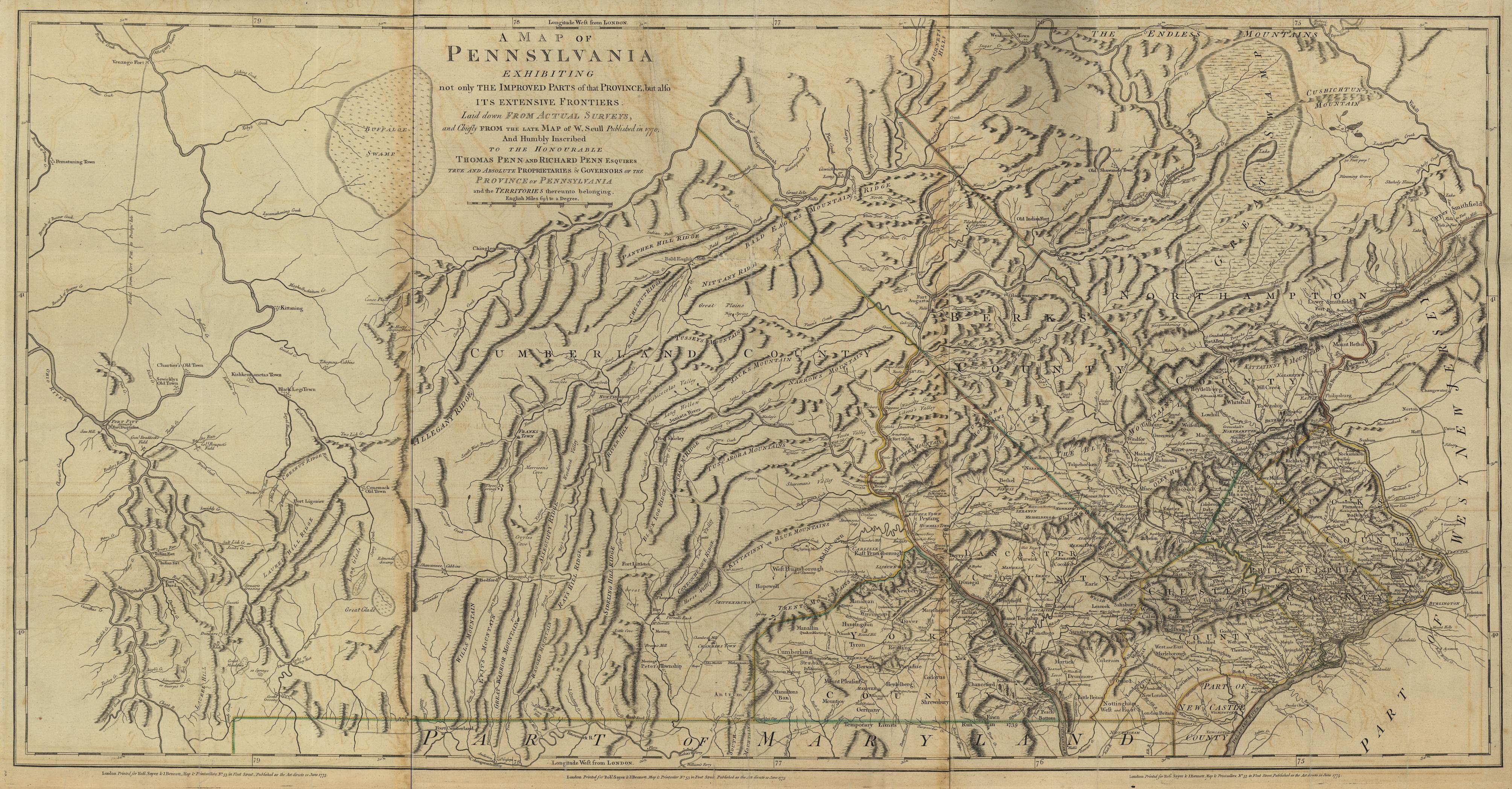
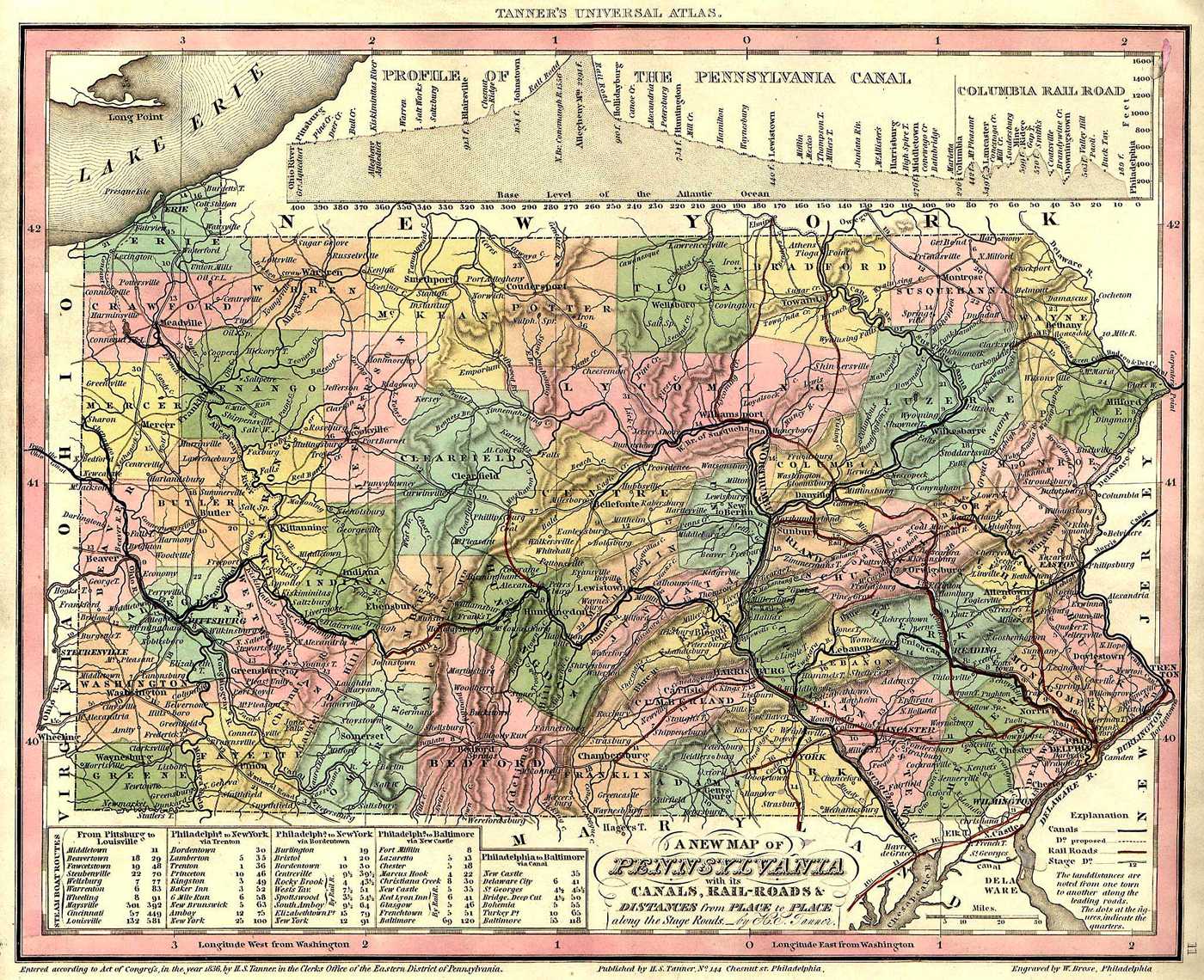
- 1836 Pennsylvania Map From The Tanner Atlas
- 1856 Map of the Canal & Rail Routes transporting Coal to New York City
- 1866 Map Of The Anthracite Coal Fields In Pennsylvania
- 1890 Railroad Map Of Pennsylvania
- 1901 Railroad Map Of Pennsylvania
- 1913 Proposed Highways Map

1796
County Maps:
- Columbia County
- Lycoming County
- 1818 Lycoming County Map by Whiteside
- Draft of the Larry's Creek Plank Road, Lycoming County, Penn'a : 18 miles long
- 1861 Topographical Map Of Lycoming County
- 1873 Atlas Of Lycoming County
- 1892 Map Of Lycoming County Townships
- Montour County
- Northumberland County
- 1818 Northumberland County Map By Whiteside
- 1850 - Proposed new "Freeland" County [denied]
- 1858 Cummings Map
- 1874 Cummings Map
- Union County
Town Maps:
Allenwood
Danville
Hughesville
Jersey Shore
Lewisburg
- Fowler Map
- Baily & Co Birds Eye View
- Sanborn Fire Maps
- Milton
- Map Of Early Settlements In Milton Pa
- 1847 Milton From Red Hill
- 1848 Nagles Addition To Milton
- 1870 Map Of Milton
- 1879 Milton Annex
- 1883 Fowler Panoramic Map
- 1892 Shimer Addition
- Sanborn Fire Map
Montgomery
Montoursville
Muncy
Shamokin,
Watsontown
Williamsport
Misc. Interesting Maps
- 1764 A topographical plan of that part of the Indian-country through which Colonel Bouquet marched in the year, 1764
- 1777 Map Of The Seige Of Mud Island Fort
- 1875 Philadelphia 100 Years Ago
- 1876 Birds Eye View of Fairmont Park Centennial Buildings
- 1890 Valley Forge, Fowler Map
- 1926 Kite View Of The 1926 Sesquicentennial in Philadelphia
================

Find More Local History & Stories Here:
================
Find More Maps:
Finish indexing from here:
https://www.loc.gov/search/?fa=location:pennsylvania&q=Northumberland+County
Hagley Digital Collection
David Rumsy Map Collection
No comments:
Post a Comment
I'll read the comments and approve them to post as soon as I can! Thanks for stopping by!