
The Montgomery Pike is the highway from Allenwood, over the mountain to Williamsport. An early article on the road states that the Montgomery Pike cut eight miles off the distance between Williamsport and Montgomery, as compared with the roundabout route through Muncy.
As early as 1805, the path existed as the Loyalsock Gap. On March 26th 1821, and act was passed by the Pennsylvania Assembly to open and clear a road through the gap.
In 1840 the Loyalsock Gap Turnpike was incorporated, and from 1840 to 1900 it was a toll road. In 1899, the state began condemnation proceedings, the process of converting private property to public use. On February 13, 1900, toll collection ceased and the toll gates were removed. In October of 1930, as part of the expansion of US 15, the Montgomery Pike became part of the route 15 highway.

Early postcard depicting the lookout on the Montgomery Pike
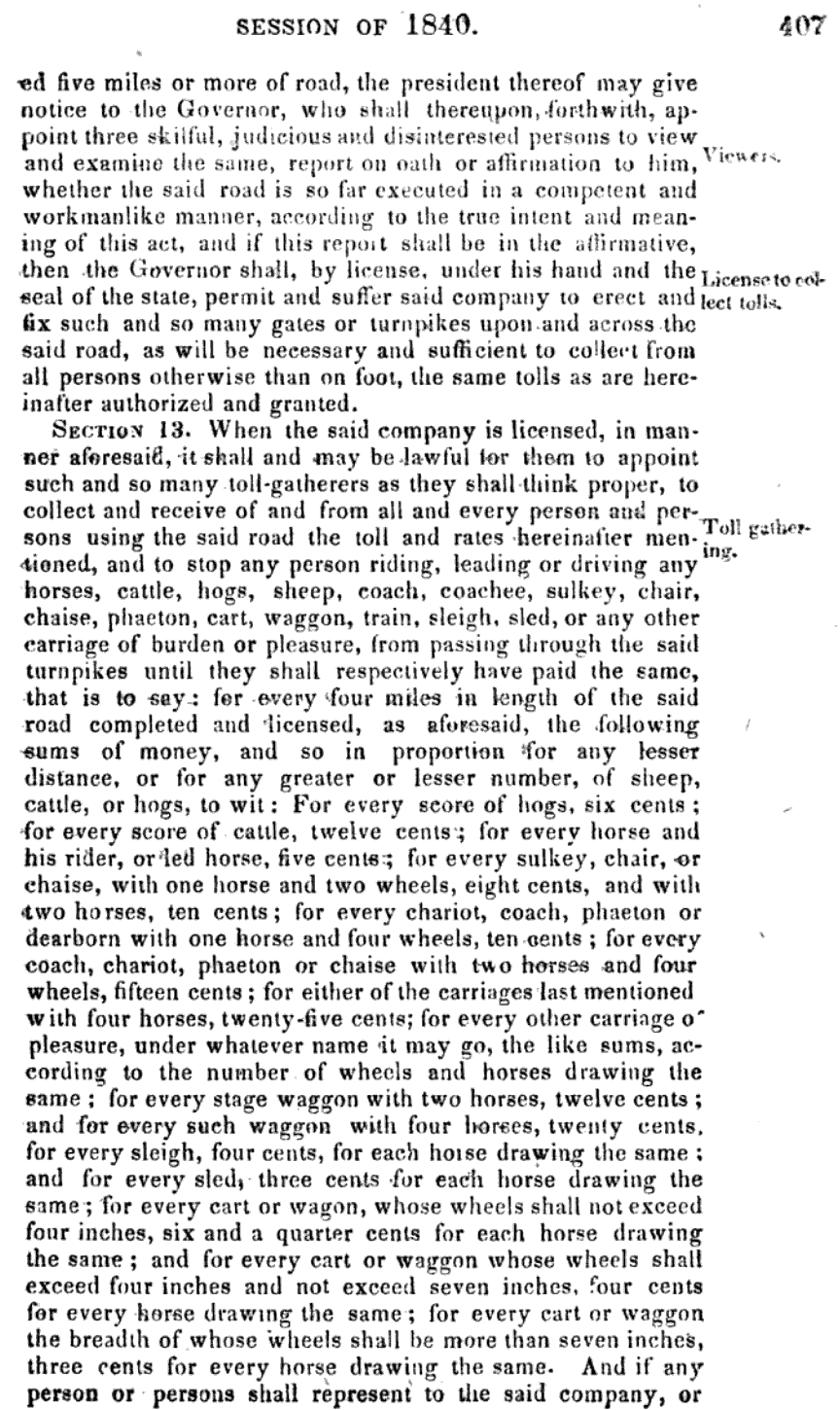
Toll rates in 1840 included:
Score of hogs - 6 cents
score of cattle - 12 cents
Horse and rider - 5 cents
Sulkey , Chair, or Chaise with 1 horse and 2 wheels - 8 cents
with two horses - ten cents
Chariot, coach, phaeton or dearborn with 1 horse and 4 wheels - 10 cents
with two horses and four wheels - 15 cents
Stage Wagon with two horses - 12 cents
Sleigh - 4 cents for each horse
In 1909, J.M.M. Gernard mentioned the Pike in his guidebook. "About five miles west of the terminus of the Bald Eagle is a deep rift, or cross-crack, known as the Turnpike Gap, through which a turnpike has for many years connected Clinton Township with the City of Williamsport."

The 1873 Atlas Of Lycoming County notes the location of the toll gate and hotel of Mrs Waltman, in Clinton Twp.
The act of incorporation for the turnpike, in 1840, granted the president, managers, superintendents, engineers, artists, and chain bearers the right to enter all of the property in which the intended turnpike road may be thought proper to pass. This area was described as:
Beginning near George Porters, through Loyalsock Gap, to the line dividing Washington and Clinton township at the juntion of the state road leading to Muncy with the present road leading to Uniontown [today Allenwood] through Loyalsock Gap to Williampsort int Lycoming County.

On April 11th 1916, 82 year old John Fowler of Montgomery walked the 11 mile pike from Montgomery to Williamsport. He made the return trip by train, joking that he preferred to walk, but owing to the wretched condition of the roads he decided to ride.

This postcard view from the lookout was mailed in 1917

Here's a closer look at the sign in the above postcard
"One of the earliest improvements in Lycoming county at an early day was the Loyalsock turnpike, which crosses the mountain through Loyalsock gap and has its beginning in Armstrong Township. Until only a few years ago it was a toll road with a gate at the top of the mountain. It was built originally as a short cut from Williamsport to Northumberland and was followed by the old stage coaches." - Meginness

Williamsport as seen from the curve on Montgomery Pike
In September of 1925, plans were made to improve the pike. An oil bound macadam was expected to be used, "six or eight inches of crushed stone being covered with a tarvia dressing."
 Williamsport as seen from the curve on the Montgomery Pike. Note that the same railing can be seen in the above colorized photo.
 Williamsport as seen from the curve on the Montgomery Pike. Note that the same railing can be seen in the above colorized photo.
The above photo was taken by D. Vincent Smith. Smith was a prolific photographer in our area from the 1890s into the 1950s. He traveled by bicycle, carrying his box camera with him, long after the automobile became common. "The death of D. Vincent Smith, the photographer on a bicycle, brings to a close one of the most interesting careers in Lycoming County. Sticking to a bicycle after faster means of transportation became available was not a fad for Mr. Smith. He didn’t do it to attract attention, instead he considered it a healthy way to exercise and an ideal way to stay close to his job." - Williamsport Sun, July 1955

1930
.jpg)
Montgomery Pike Lookout, looking toward Montoursville. On the extreme right, the Loyalsock Creek can be seen


The pike was reconstructed and widened beginning in 1939.
As part of this project, the one room Pine Street School in Montgomery was demolished, and the Eagle Grange No 1 building was moved. The Eagle Grange building was constructed in 1887, and still stands today along route 15.

The Montgomery Pike, 1940, during the project to widen and improve the road. The hairpin curve was removed during this time, and the road was paved in concrete. A 3rd lane was added at this time.

February1940

Today Route 15 runs slightly to the west of the original old gap road. Old Montgomery Pike road is shown on google maps. The old road had a spur leading off the Sylvan Dell, a popular beach and amusement area at one time.

In October of 1930, the section of highway known as the Montgomery Pike officially opened as part of US 15, the road running from New York to South Carolina.

In July of 1966, "The rock pile on the north side of the road will be removed creating a wider view of the panorama from that point and the highway will be widened to four lanes for about a mile in the same vicinity."
============
 In 1900, the Philadelphia Record wrote of The Devil's Turnip Patch, along the Montgomery Pike.
"On the top of Bald Eagle mountain, Just where the old turnpike breaks- over the brow down Into Black Hole valley, Is a queer field of rock, which years ago was christened "The Devil's Turnip Patch."
Read more about the Devils Turnip Patch here:

The Pike Drive In Theater in Montgomery is named for the road it borders
Note - there is was also a Pike Drive in on the Montgomery Pike in Montgomery Ohio.

On July 31 1973, a tractor trailer carrying 20,000 lbs of frozen chicken crashed on the pike. Although the owner of the truck hired boys to clean up the mess, many pieces were stuck in the rocks, and on August 6th, the Sun Gazette reported that the the Department of Agriculture was doing everything they could to "get the stench down", but they were running into difficulty. Loads of lime were being brought in to spread over the area.
=============
MISC NOTES
=============
Ivan Groom owned and operated a diner on the Montgomery Pike

September 1925

November 1929

July 1940

November 1947
====================
The lower farm was originally owned by John Gibson, one of the best known and well beloved men in this section of Pennsylvania, and one of the most enterprising of his day. He was not only a successful farmer, but a progressive man in all lines of material development. He was one of the first directors of the Loyalsock Turnpike Company and also an active spirit in the building of the first bridge over the Susquehanna River in Lycoming County on the site of the present Market Street Bridge. - Meginness, Otzinachson
==========================
In the receipts and payments of the treasury of Pennsylvania, January 1821:
"No. 339. Paid an order drawn by the commissioners of Lycoming county, in favor of Henry Billman, one of the contractors for opening and clearing the road through Loyalsock Gap, our of the moneys appropriated for that purpose, by an act of assembly twenty sixth March 1821"
John Shaeffer was also paid for the same purpose [No. 340], as was Michael Kaeler [No 559] John Piatt [No. 1196] & William Gibson [No 1125] The receipt for Gibson states that he completed the section of the road contracted for him. He was paid $13.50, in May of 1823. That would be roughly $2,753.42 in 2022.
=========================
The Loyalsock Gap Turnpike Company was incorporated on April 16 1840.


.jpg)
August 1923
Thank you for another fascinating article. I am related by marriage (although subsequently divorced) to Ivan Groom who you mention had a diner along Montgomery Pike. I’m curious if you have other information on him or the diner. He was an entrepreneur who with my great aunt operated a dairy and made ice cream in Montgomery. As I understand, he had at least 2 ‘stands’ along Rt 15 where they sold the ice cream. He actually became involved with a younger woman working at one of the ice cream stands, divorced my aunt, and moved to Ohio where he built a successful business making and selling ice cream. I really don’t know much about him for obvious reasons, which is why I ask if there is information you have found in your research. Thanks again.
ReplyDeleteI have come across several photos of Grooms trucks and restaurants. He had three locations that I know of, one in Montgomery, one on the pike, and a store in Williamsport at the corner of fourth and Walnut streets. The ice cream was manufactured in Montgomery, behind the Eagle theater on Brook Street. You should definitely contact the Montgomery Historical Society, I would bet they have a good bit of information on Groom. Hope that helps!
DeleteThe postcard from 1917 showing a sign for the Williamsport airport is wrongly dated. The postcard could not have existed prior to 1929 as the airport didn't even start being built until 1928 and didn't open until 1929.
ReplyDeleteWhile I agree that The Williamsport Airport did not open until 1929, the sign may not be referring to the town airport we know today? There were a lot of smaller, early airports - basically landing fields and a shed for storage and parts. I can't be certain, and I can't find the original postcard to double check that I got the date correct. It may help to know when the golf course existed, if it did not exist until after 1917, then the date is definitely wrong.
DeleteI am constantly amazed by the content of your articles and writing style. Thank you so much for your hard work and the ability to enlighten the readers to the local wonders, that we unfortunately take for granted, most of the time.
ReplyDeleteJust always wondering who built the rest area on top of the mt? It has old remnants that suggest it was used a lot more a long time ago & structures that remind me of CCC work?
ReplyDelete