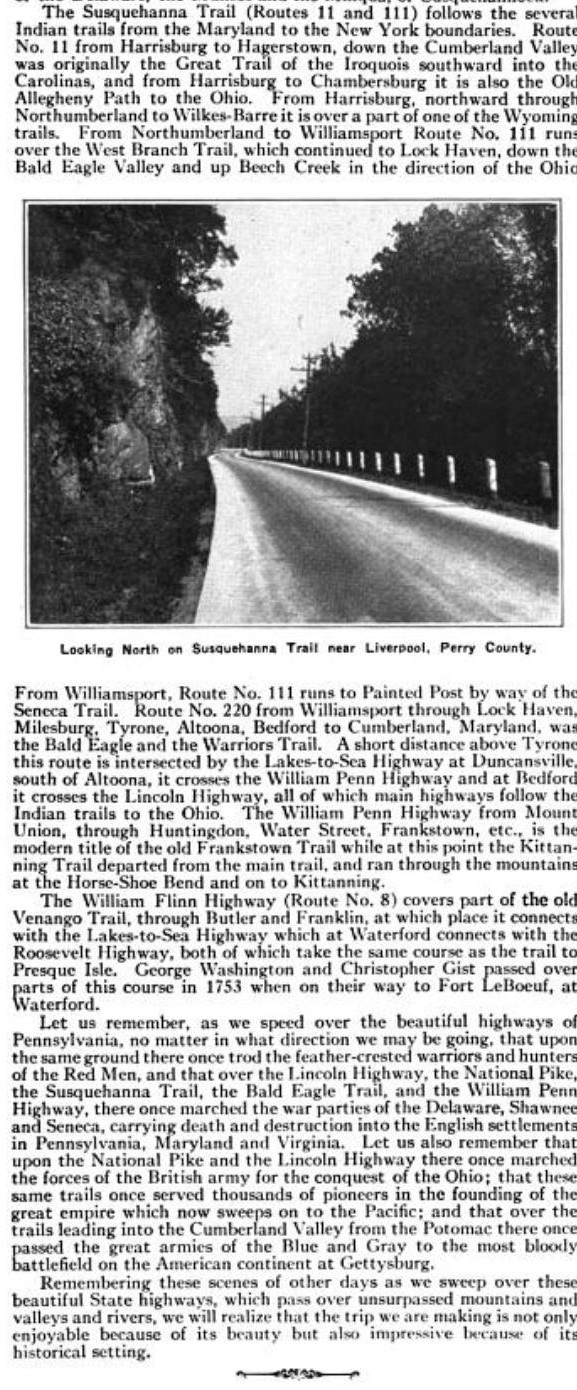
Saturday, June 7, 2025

The Susquehanna Trail - From Niagara Falls To Washington D.C.


"The Susquehanna Trail Association" was formed at a meeting  in Williamsport on December 15th 1916.  

A meeting was held at the courthouse at Williamsport on February 2nd 1917, to further the development of the Susquehanna Trail proposition.  Dr Charles T. Aikens was president of the association.


The Selinsgrove Tribune reported "Just what course the trail will take from Williamsport will be one of the important features to be threshed out..  Keen rivalry exists between several of the towns to have the road go through their village."


1938 - Susquehanna Trail "south from Fry Bros Turkey ranch on the old Route 15 towards Trout run but before the old Tomato curves."

The Tribune also said "the trail is by no means a project of a recent date.  it has been a more or less public issue for a century."  The portion of the road between Harrisburg and Elmira was the "least improved part..  in spite of the fact that road builders have been pegging the project for 100 years.

That seemed like a bit of an exaggeration to me, until I read:

The first record of the Susquehanna Trail appears in the minutes of the first court of quarters sessions held at Fort Augusta near Sunbury on may 26th 1772.  "There were present many inhabitants from Northumberland County who resided along the west brand of the Susquehanna river and places adjacent praying that proper persons be appointed to lay out from the end of the road opened lately and ending at Fort Augusta, a road to the line of the late Indian purchase at Lycoming Creek."  Marcus Huling jr of Milton was one of the men the court appointed to lay out the highway.  It was authorized by the court in October of 1772.


However, like our road projects today, there were many difficulties and delays, and work on the project didn't begin until 1775, when Col. Antes and others laid out a bridal path form the mouth of Bald Eagle Creek to Sunbury.  No effort was made to make this a straight road - it simply went around trees and other obstructions.  "In a short time, it had become impassable due to it's poor construction, and traffic turned to the river, passing up and down the valley in keel boats."

Years later, the bridal path was widened, and "the horn of the stage driver heralded the beginning of rapid transit up and down the Susquehanna."  


"This Good Roads Movement closely followed the model created by the Lincoln Highway Association.  The Susquehanna Trail Association was organized for the purpose of promoting and advising on an improved road between Harrisburg and Williamsport (already known as State Route 4) and continuing northward to connect to improved roads in New York State."

The Proposed Route for the Susquehanna Trail
As published in nearly every local paper along the route
January 1917

That "keen rivalry" over the route, filled newspapers in early 1917.  Bradford and Tioga in particular, were vying for the route to pass their way.


SUSQUEHANNA TRAIL ROUTE CAUSES DISPUTE

"Delegations From Tioga and Bradford Counties Clash at Williamsport Meeting Williamsport, Pa., Feb. 3.-Delegations from Tioga and Bradford counties advocating different routes for the northern lap of the proposed Susquehanna trail clashed at a meeting attended by 500 good-road enthusiasts, representing every county in northerner, central Pennsylvania. The large court room was filled during the entire afternoon as the rival delegations presented their claims and fought for what they termed justice in road matters. The Tiogans are asking that trail, which is a proposed improved highway connecting Harrisburg and Elmira, N. Y., follow the old road from Trout Run through Liberty, Blossburg and Mansfield.


This highway was laid out in 1796 to connect central Pennsylvania with central New York state and was used as a post road. Bradford county contends the better route is up Lycoming creek over a road ordered built by the legislature 100 years ago."


The proposed route that "turns to the north and west at trout run and follows what is called The Williamson Road " was the Tioga Route, and they formed a Williamson Road Association to promote this option.  A nearly full page article in the Public Press spelled out all of the reasons the Bradford County delegate found this route to be problematic.


The history of the Williamson  [or Blockhouse] road goes back to 1792, and is explained in a 1923 article in the Harrisburg Patriot News "Now & Then" column.  I've included the column at the bottom of the page under "READ MORE"

Entire pages of newspapers were dedicated to the Bradford/Tioga Dispute. There were still 3 column articles over the dispute in 1920.

In 1921, the dispute was between a Montgomery Route, and a McEwensville Route. [article included at the bottom of the page under READ MORE]


This was not the only dispute - it seems nearly every town in the valley was squabbling, and rumors of possible route changes were published in nearly every issue in 1917.
But the most puzzling dispute to me, is York and Gettysburg.  I'm not questioning why the towns were squabbling - merely Williamsport's apparent refusal to accept the decision. 


The Susquehanna Trail expanded through York in 1918


In the 1920s and early 1930s, the Williamsport Chamber of Commerce published a yearly booklet featuring the hotels, restaurants, and stops between Washington D.C. & Niagara Falls - along the Susquehanna Trail. 

The Williamsport Chamber of Commerce however, stuck with maps showing the trail passing through Gettysburg - even though the decision had been years earlier, for it to pass through York instead.  


"The officially designated Alternate Susquehanna Trail route from Harrisburg, through Gettysburg and Frederick, to Washington, D.C. becomes the preferred Trail route of the Williamsport Chamber of Commerce. They heavily promoted this Alternate Susquehanna Trail route, long after the Trail officially opened; many times not even indicating the primary Susquehanna Trail route went through York." -Yorkblo

========================

At the February 8th meeting, it was decided to make Williamsport the permanent headquarters for the Association.  A legislative Committee was appointed, and an emblem was designed.

A souvenir pin - Williamsport On the Susquehanna Trail

Susquehanna Trail Office at Williamsport Williamsport, Pa., Feb. 8. 
At a meeting of the board of governors of the . Susquehanna Trail Association, formed to secure an improved highway from Harrisburg to the New York State line, it was decided to establish permanent headquarters in Williamsport. 
The following legislative committee was appointed: 
Senator Charles W. Sones, Williamsport;
Charles E. Dewey, Bradford; 
W. C. Murdock, Milton:
 Frank Marvin, Tioga; 
Henry T. Albeen, Potter county; 
Harry Knight, Sunbury; 
Representative Sampsel, Snyder county;
 B.C. North, Selinsgrove. 
An emblem in the form of a circle with Indian head in the center and "Susquehanna Trail" emblazoned under the head was adopted..

In 1924, the route was  to be marked "with the Susquehanna Trail Association emblem, an Indian head, the design to be stenciled In colors at frequent intervals along the highway"
[I'm still looking for a photo of the emblem]

A Celebration Event, for when the road was completed,  was planned for July 15th 1923  but "when the time drew near, it was seen that the contractors could not complete the stretch at Selinsgrove."  The celebration was moved to September. But in August, it was announced that the stretch in Montoursville, and the stretch between Liverpool and Selinsgrove would not be completed until the middle of October.

Then, with the road complete,  there were disputes over where the celebration event would be held.  Williamsport had always intended to host the event, but Harrisburg thought it should be located somewhere between Williamsport and Harrisburg.

The Grit reported that "Now everything is up in the air and the general sentiment is that the affair should be abandoned."


In March of 1924 plans were once again tentatively being made for a celebration - but if it ever occurred, I found no record of it.


====================


The completed Susquehanna Trail was described in a July 1924 issue of the Harrisburg Courier: 

Motorists who wish to see mountain scenery and enjoy a tour historic, interest, Susquehanna should pian to drive over the Susquehanna Trail.  Taking its name from the Susquehanna Valley, the  trail is an unbroken concrete ribbon 450 miles long, connecting Washington, D. C. and Niagara Falls. Of all the scenic routes the country, especially in the Eastern portion, it may be said that the trail surpasses any other in variety scene, in beauty of prospect and historical interest. 

Leaving Harrisburg, the trail follows the eastern bank of the Susquehanna to Clark's Ferry, where it crosses the old-fashioned covered bridge just above the junction of the Susquehanna and the Juniata Rivers--the same "Blue Juniata" fabled in song and story. Twenty-six miles further the tourist comes to Selinsgrove, which place is located Susquehanna University, while a few miles more brings Penn's Creek, the scene an Indian massacre in 1755.


 Crossing river again to the eastern bank the tourist arrives at Sunbury, once an Indian village known as "Shamokin" but now a thriving little city. It was here that Thomas A. Edison made first successful attempt to light a city by means of electric lamps and it was to Northumberland, just across the north branch of the Susquehanna, that Joseph Priestley, discoverer of oxygen, came to live in 1795. Priestley's house is still standing and is open to visitors. 

Sunbury stands sentinel at the gateway to the West Branch Valley, for here the north and west branches of the Susquehanna unite. Passing thru Northumberland, the Susquehanna Trail enters the West Branch Valley and the scenery with every mile increases in ruggedness, in wildness and in grandeur.  Lewisburg, county seat of Union County, is the next stop, and here is found Bucknell University, established in 1846. 


Four miles farther on, the tourist arrives in Milton, near which may be found the site of Fort Freeland, while a few minutes' more driving finds the historic Warrior Run Church. Muncy, also noted in the early history of the colonies, is soon reached. It was in this vicinity that Captain John Brady, famous Indian fighter, was killed in 1799, and where Conrad Weiser visited an Indian village of the Susquehannock Tribe in 1737. At Muncy, leading to Susquehannock, Eagles Mere branches off to the right.


Ten miles farther on, at Montoursville, is found the grave of Major General John Burrows, of Revolutionary fame, while just beyond the limits of the town, the trail crosses Loyalsock Creek, a stream famous for its trout and bass fishing. It rises about miles to the north and literally cleaves its way through the mountains which overshadow it. "Swimming holes" abound and summer cottages line its banks. 

Four miles farther on the tourist enters Williamsport, the Queen City of the West Branch Valley, a place of diversified industry and one of the most prosperous and progressive cities of its size in the State. With a population of approximately 50,000 people there are now over eighty-five manufacturing concerns in Williamsport, representing 50 disestablished, tinct lines of endeavor and employing about 11,000 persons.


Forty years ago it was the foremost lumber city in the country, its sawmills having a capacity of more than 3,000,000 feet a day, but with the exhaustion of the forests, capital was diverted to other industries. It is a city of beautiful residences, as the majority of its inhabitants own their own homes. 


Williamsport is surrounded by natural beauties and the streams and forests are filled with game and fish. Many make it their headquarters for a few days--days to be spent in excursions the forests, streams and lakes with which country abounds. tow The tourist does not leave Williamsport far behind before he is one the banks of Lycoming Creek, another famous Indian stream deep down in a narrow valley between mountain ranges which grow bolder and grander the farther he advances.

Along The Williamson Rd

At Trout Run suitably named the trail leaves Lycoming Creek and follows the route of the famous Williamson trail; a road cut through the primeval wilderness by the pioneer by whose name it has been known ever since. This road shortened the route to New York State by a hundred miles. 

Boss Mountain - Susquehanna Trail Top - Highest Altitude

Passing through the valley of the beautiful Tioga River the trail runs north to the State line, New York State, where the valleys touching Liberty, Bloomsburg, Mansfield and Tioga, until it emerges in widen and the "Finger Lakes" are to be found.  At Painted Post the tourist finds an Indian village of the Cornplanter Tribe, remnants of which are still extent.


 All Concrete Roads

 From this point on to Mount Morris, which overlooks a valley studded ist [Note - that's an accurate transcription.  I'm uncertain what is missing] has a gradual ascending grade from which he catches glimpses to the right and left, first of hilly, then of bolder scenery until he reaches Batavia, from which point the trail runs down the hill to Williamsville, where the tourist may take the left-hand road to Buffalo or, keeping to the five miles away. Thus, from Washington or Philadelphia to Buffalo and right, continue on to  Niagara Falls, the tourist finds a solid concrete road.

Caulkins Post Card - Susquehanna Trail Morris, Pa

It should be remembered that the Susquehanna Trail at Frederick, Gettysburg, Harrisburg, Sunbury, Williamsport and other cities along the line, may be entered by macadam or concrete roads which connect it with hundreds of other cities and towns, each of which has its own peculiar interest and attraction. Among these lateral highways may be mentioned the Lincoln Highway, the William Penn Highway, the Horseshoe Trail, all in Pennsylvania, and the Empire State Highway, in New York.

 Through Pennsylvania the Susquehanna Trail poles are marked with blue marks for stops and signals, and the tourist has only to watch for the blue stripes. 


Features of the Susquehanna Trail are the side trips which may be included on a tour, and which are decidedly out of the ordinary. Williamsport is especially favored in this respect, as from this central point it is possible to reach Eagles Mere, State College, Penns Cave, Ole Bull's castle, the site of the Pine Creek Declaration of Independence, points on the Loyalsock and other places of beauty and historical interest in Central and Northern Pennsylvania. 


The route to Eagles Mere, a sheet of water covering 200 acres on a mountain top more than 2000 feet above sea level, lies through Muncy, Hughesville, Picture Rocks, Tivoli and Muncy Valley, a part of which is concrete and the remainder improved State Highway. Eagles Mere is one of the most celebrated resorts in Pennsylvania, and its lake of pure spring water furnishes ample opportunity for all aquatic sports, while its sporty eighteen-hole golf course, cut through a forest of virgin timber, is above the average.

While in the vicinity of State College, the tourist should not miss most wonderful in the country and providing a boat ride finer than anything Penns Cave, beyond doubt one of the of the same sort in Mammoth Cave. It is fourteen miles from Bellefonte on the way to Williamsport by way of Millheim, Mifflinburg and Lewisburg.

Advertisements, addresses, and souvenirs - the hope was that the Susquehanna Trail would bring tourists to local towns - similar to the Lincoln Highway.

Susquehanna Trail bookmark

Tourist camps, like the Blue and White Cabins in Selinsgrove, sprung up all along the trail


In November of 1924, patrolmen were stationed all along the Susquehanna Trail in a campaign against glaring headlights.


=========================
READ MORE
========================

The Susquehanna Path [Indian Path - Not the Susquehanna Trail Rd] stretched from present day Harrisburg (then known as Paxtang) to Sunbury (then known as Shamokin).  This path was used readily by Colonel William Clapham’s regiment in July of 1756 when they traveled north to Shamokin to build Fort Augusta.  There is sufficient evidence to conclude that the Susquehanna Path ran along the west shore of the Susquehanna, connecting the mouth of the Conodoguinet near Lemoyne to the Juniata mouth near Juniata. 
The Susquehanna Path is now followed by U.S. 22 from Harrisburg to Amity Hall and by U.S. 11 and U.S. 15 from Lemoyne to Sunbury.

On February 8th 1917, a permanent headquarters was established in Williamsport, for the Susquehanna Trail Association.  

In May of 1923 the Grit reported that arrangements had been made to have moving pictures taken of the Susquehanna Trail and country in vicinity.  The American Highway Education Bureau at Washington D.C. was to take the photos.

January 1917


Jan 1917

SIGN PETITIONS FOR GOOD ROADS 

D. A. R. Chapters Along River Ask For Establishment of "The Susquehanna Trail" 

Bradford Chapter, Daughters of the American Revolution is asking the chapters along the Susquehanna river Harrisburg, northward, to co| operate with them in their work for the establishing of "The Susquehanna Trail and Good Roads." The road will start from this city and continue 146.6 miles to the northern boundary of Pennsylvania, making a direct water grade route from Harrisburg to Elmira, N. Y., by way of Selinsgrove, Sunbury, Lewisburg, Milton, Williamsport, Canton and Troy.

The road will follow the trail that Col. Hartley and his troops took in the fall of 1778 on their famous expedition of relief to the settlers between the west and north branches of the Susquehanna. A State highway would make an appropriate marker of this route of such great historical interest. Col. Hartley destroyed all the Indian towns along the way and had a battle with the Indians at Cedar Ridge, killing a famous chieftain.

Petitions have been sent Harrisburg Chapter member D. A. R. to sign and every is asked to use her influence among the Legislators to support the "Susquehanna Trail."


Letter from Armstrong in McEwensville, giving an extensive history of the area along the route.

In 1921, the dispute was between a Montgomery Route, and a McEwensville Route.


1923 - the Road is almost completed
Then & Now
An Explanation Of The History of the Williamson [or Blockhouse] Road


The Susquehanna Trail Follows Old Indian Paths
Pennsylvania Highways, 1929


I think this bridge was actually completed in 1926 - it was built after the covered  bridge burned in 1923.  I also think it crosses to Snyder County, although possibly I have the county lines wrong...  it would be near the county line for either county.


========================
Many of the Susquehanna Trail Post cards were originally sold in this folder in the 1920s.  It also included a number of well known post cards of Williamsport buildings.


===========================
Williamson Road 1792 – 97
Submitted by Chester P. Bailey

The Williamson Road built in 1792-96, by Charles Williamson, to open the Genesee land in N. Y.; from Trout Run, it cut through the wilderness to Lawrenceville by the same general route of U. S. 15.
  1. Charles Williamson, Land Agent for the Pulteney Estate in N. Y., arrived in America from England, November 1791.
  2. Charles Williamson petitioned the Pennsylvania Assembly to build a road through the wilderness to Northern Penn.
  3. February 1792, Williamson blazed the Indian Trail to the Genessee River in N. Y,
  4. April 10, 1792, the Assembly passed an Act; for the purpose of viewing and laying out a road from the Loyalsock Creek near Williamsport to the Rioga River and to 109 mile stone, state line, Lawrenceville.
  5. June 1792, Williamson hired Robert and Benjamin Patterson with a company of woodsmen to build the road.
  6. Later that summer 200 German men, women and children arrived. They were sent on to help on the road.
  7. A blockhouse was built at the site of Liberty for supplies.
  8. The road cut over Bloss Mountain and down to Peter’s Camp on the Tioga River, Blossburg.
  9. They moved north along the Tioga River, fall of 1792.
  10. The road builders reached the area about 2 miles south of Mansfield and cleared a 2 acre site for camp.
  11. Facing starvation as supplies ran out, they were rescued by Canoes from Painted Post. The women and children and sick were taken to Painted Post, the men took the land route, thus the name Canoe Camp.
  12. The road builders returned in the spring to finish the road to Bath, N. Y,
A section of the Appalachian Thruway in northern Pennsylvania, a major north-south highway will be two hundred years old in 1992. The section is known locally as the Williamson Road and extends from Lycoming County through Tioga County to Painted Post, N.Y. It all started with the arrival of Charles Williamson in America for the second time in 1791. He had come this time to build a road through the wilderness of northern Pennsylvania to lands of Sir William Pultney in New York State. The route that has borne his name through the years is U S 15 in Tioga County.
Charles Williamson was a well educated and energetic young Scotsman who had come to the colonies the first time as a British soldier during the Revolution. He apparently spent some of his tour of duty in Massachusetts where he married Abigail Newell. After the war he returned to England. He arrived in Norfolk, Virginia with his American wife and children in November 1791. Williamson had been appointed by the owners of the Pultney estate as their agent to manage its million acres in western New York. He was thirty-four years old.

New York had a law prohibiting alien ownership of state land. Williamson’s first act was to secure American citizenship which was not difficult with his American wife.

Robert Morris of Philadelphia owned large acreage in west New York and northern Pennsylvania. If Williamson had any question as to the best way to get to the Genesee country in New York, by land or by water using the Susquehanna and the Chemung rivers. Morris probably helped him decide, their lands joined.

The land route was an Indian trail that lead through the wilderness joining the Sheshequin trail along Lycoming Creek. It ran up Trout Run to Liberty and down Balman Run to the Tioga river and down the river to Painted Post. The present location of Blossburg, Covington, Mansfield, Tioga, Lawrenceville and Painted Post on US 15 today are on that trail. In New York the Indian trail went up the Cohocton river through Bath and on to an important Indian settlement on the Genesee river.

Williamson and Morris set out to convince the Pennsylvania Assembly and Governor Mifflin that it was to the advantage of the Commonwealth to build a road through the wilderness and open northern Pennsylvania to settlement.

Williamson made an application to the Assembly for a grant to assist in the construction.

Agent Charles Williamson was not one to wait for things to happen. He was anxious that the work get started and also inspect the land he was commissioned to settle and sell. He could not be convinced that it was dangerous to travel through the wilderness in the dead of winter. Therefore he put his family in suitable quarters and proceeded by horse, sled and on foot in February 1792 to the western border of the Pultney estate, the Genesee river. It is believed that John Johnstone, a faithful Scott, who had come over seas with the Williamson’s accompanied him. The trail having been blazed he returned to Philadelphia.

On April 10, 1792 the Assembly finally passed an Act for the purpose of viewing and laying out a road from Loyalsock Branch on the Susquehanna to the Towanisco Branch of the Tioga river and to the 109 mile stone, (State line at Lawrenceville)… The Assembly gave Williamson 100 pounds in silver.

In the meantime Patrick Calquhonne, a part owner of the Genesee tract, had agreed to send settlers and laborers to Williamson. He arranged with William Berezy, a German picture salesman, to select a colony to send over. The German got his company from Hamburg. They were willing to leave Germany for fear of being picked up for vagrancy, for they were loafers off the streets. There were about four hundred men, women and children. Calquhonne never saw the Germans.

By June 1792 Williamson had hired Robert and Benjamin Patterson as guides. The Patterson’s were known guides and Indian scouts from Northumberland County. They were put in charge of a small corps of woodsmen and a group of Englishmen to build the road.

Two hundred of the Germans arrived in Philadelphia in late summer under the guidance of Berezy. Robert Morris loaded them onto wagons and sent them on to join the road builders.

The road came through the wilderness to Trout Run, over Laurel Hill to the Block House (Liberty) where the women and children were left while the road builders forged ahead. The Block house was also used to store supplies. It was later to be used as hotel. It was a log structure approximately 20 X 40 feet.

The road builders continued north over Briar Hill (Bloss Mountain) and down to the Tioga river. Here they set up another camp, named after a baker and called Peter’s Camp. He built ovens and supplied the camp with bread. The Petersons discovered coal in the area. Peter’s camp site is within the Blossburg limits today.

As the road builders came down the Tioga river valley to the present site of Canoe Camp their supplies were running out, with winter coming on two acres were cleared and camp set up. After supplying the camp with a good supply of game, Patterson and several of the Pennsylvania woodsmen went to Painted Post over the Indian trail. They returned with supplies and canoes. The women and children and sick were floated down to Painted Post. The men went overland. They arrived at Painted Post in December 1792.

The road builders returned in the spring and the road was finished to Painted Post, up the Cohocton river to Bath. The Williamson Road was finally finished in 1796.

The Williamson Road south of Mansfield from Canoe Camp ran in nearly the same road bed as now. In town it approached the borough down East Main street and at the park followed the route north later used by the railroad. It crossed Corey Creek near the milk plant (Boro garage) and went up the hill and along the west side of the cemetery. It crossed the river and recrossed at about where the by-pass crosses. The road stayed along the river through Lams Creek (old site) up the hill, down to Mill Creek and on to Tioga, basically the old 15 route, moved by the U. S. Corps of Engineers dam.

Williamson left the road builders in the wilderness of Northumberland (Lycoming County) and returned again to the Pultney estate. He had boundless energy and began developing his ideas as to what he wanted the settlers to find when they arrived with the road builders to the area.

In 1793 he made his first clearing in Steuben County, it established the site of Pultney Square in Bath, N.Y. He believed that a settlement of several buildings would encourage others, and established his wife and family in a large log house. He built roads and started his plan of a city on the Genesee River. This he named Williamsburg after Sir William Pultney. He could not wait for the settlers for he felt a city would attract the wealthy and socially prominent country gentlemen from Maryland and Virginia.

He built inns, mills and schoolhouses. He started a newspaper, erected a theatre and layed out a race track. He advertised in the Albany newspaper that a fair and races would be held. The fair was a success and the people came, but to add to the difficulties of the time was that the settlers he had planned on were not there. The settlement got off to a poor start because of the "Hamburg Scum" as the Germans were called. They had an emigration agreement with Berezy. They wanted land, houses, cattle and tools. The women wanted spinning wheels, flax and wool. There was some trouble and a few Germans were arrested and taken to Canandaigua. Some returned to Philadelphia with Berezy. Most of them, knowing they had escaped from German law just began to fade away into the woods and many migrated to Canada.

The Pattersons remained in the Painted Post area and operated one of the inns Williamson built in 1796. It was known as the Benjamin Patterson Inn and is maintained today by the Corning-Painted Post Historical Society on west Pultney street, Corning, N.Y.

Slowly the travelers began to come as the news of Williamson Road spread. Charles Williamson was a charmer and smart in advancing the information. He put post riders on the road between Bath and Williamsport ev ery week. It is said that he liked to dress in the latest styles from New York City and to entertain guests. He loved well bred horses and would ride at speeds enough to make his fine blue cape fly out. Some outstanding visitors came along them the Duke de la Rarfoueauld Lianott. He came from the French Colony at Asylum in Pennsylvania. Three Virginia gentlemen came to visit. They traveled over the Williamson Road in a fine coach with a slave on horse back and leading a pack horse. These men returned three years later in 1797 to buy a large track. This is of historic note because it became the site of Rochester. Charles Williamson did not see this happen for he was relieved of his position in 1801. The owners of the Pultney estate dismissed him. They claimed losses of $1,000,000. Williamson returned to England and turned up later as a messenger for the British government. He died at sea returning from the West Indies.

Aaron Bloss, founder of Blossburg and others in their quest to ship coal to Williamsport petitioned the state legislature in 1812 for $10,000 to improve the Williamson Road from Blossburg to Williamsport. They were refused.


No comments:

Post a Comment

I'll read the comments and approve them to post as soon as I can! Thanks for stopping by!