
============================
An Index Of Stories, History, Photos, and Resources
Related to the Canal along the Susquehanna River
particularly in the area of the North and West Branch & Susquehanna Divisions

The above photo is used on a variety of postcards. I've seen it labeled Milton Pa, Jersey Shore Pa, Rochester NY, 1840, ... The image is a painting by Edward Lamson Henry [E.L. Henry] 1841-1919 titled “Before the Days of Rapid Transit”. It shows a Packet Boat on the Erie Canal being pulled by a team of horses on the canal bank.
 |
 |
 |
 |
 |
 |
|
|
|
The Canal At Montoursville |
|
|
|
|
============
The Aqueducts
============

Aqueduct Photos and Information, sorted by Division
(West Branch, North Branch, Susquehanna)
Aqueduct Facebook Posts:
|  The stones from the Muncy Aqueduct were used to build the Lutheran Church. | |

===========
Boatyards
===========
 |
In March of 1872, this boat yard was owned by McCarthy, Keller & Co. |
|
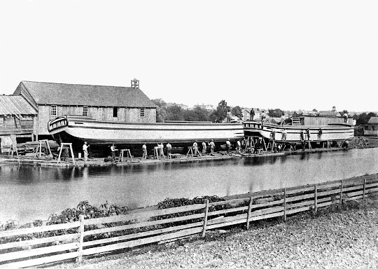
===========
Memoirs & Mentions
==============
 Milton By J.P. Kohler |
 by Mrs. Hazel Whitenight, Lime Ridge School |
 |
|
|
|
|
At the 1921 reunion, canal men recalled falling asleep while driving mules, and being awakened suddenly when they struck chilly waters. They spoke of being picked on by tough gangs in the coal regions and of the temptations of passing by orchards.
The Pennsylvania Grit reported:
Captain William Courson of Epsy recounted a story of a little colored boy who was driving mules for him one very story night, and who pleased somewhat in this manner to be taken on the boat:
"Mister Courson, I-I- certainly can't stand this kind of weather like a white boy". On another occasion when the water in the canal had overflowed a low place in the towpath, the little fellow came running back and said "Mister Courson, the towpath done got all." -
============
The Boatmen's Reunions
=============
The Boatmen's Reunions
=============


|
|
.jpg) Boating On The Canal - Yesteryears Column by Agnes Selin Schoch, 1949 |
|
====================

Susquehanna Jack, the storyteller of Frontier Pennsylvania demonstrating a horn used on Canal Boats, at the Degenstein History Buffs this afternoon. Captains would use the horn to alert the lock tenders that they were approaching, so that they could get the lock gates ready.
See the video here -
=====================
Parks & Remnants
Where The History Can Still Be Seen Locally
==================
|
|
 [North Branch Canal] |
|
|
|
|
|
.jpg)

Museum Displays
(My plan is to add these as facebook posts, and link the posts here so you can more easily see my photos of these displays)
|
|
|
|
|
|
|
==============
Books & Other Resources:
|
Amazing Pennsylvania Canals by W. H. Shank "Since he first published this book in 1960, Mr. Shank has become one of the leading authorities on historic canals in the Northeastern United States. The author has included a statewide canal map, 125 historic photos, drawings by the late Philip Hoffman, a four-color cover and tables of lock and mileage data. As founder of the Pennsylvania Canal Society and past president of the American Canal Society, the author offers this definitive work on Pennsylvania canals with the help of canal buffs throughout the Keystone state." |
 Canals Along the Lower Susquehanna (1796 to 1900) By Gerald Smelzer [I have not read this myself] |
|
|
|
|
|

=============
The West Branch Canal
By Homer Folk
"In 1829, the Muncy Line of the West Branch of the Pennsylvania Canal was started. With pick and shovel, wheelbarrows, dump wagons, and horses pulling scoops or drag lines, tremendous manpower and horsepower produced a continuous ditch with water that connected the remote parts of Pennsylvania with the cities of the east.
The standard dimensions of the canal in its cross section, termed the ”prism”, were a width of forty feet at top waterline, twenty-eight at the bottom, and a minimum depth of four feet. The chosen route through Milton had a constant sea level reading until near Cameron Avenue. There the elevation dropped, making a lock with a lift of 6.12 feet necessary. Stone walls held together with hydraulic cement (select limestone burned with clay) were one hundred and twenty feet long, with a passageway seventeen feet wide. Miter or angular joints on the inner edge of the heavy wooden gates located at each end of the lock sealed the gates, with little water loss when the gates were closed. The large square balance beams were manually operated to close the gates. The lock tender, who lived in the state house (lock tender’s house), was responsible for operating the gates.
To the west of the canal was the former Limestone Run creek bed . From this source and the marsh to the west of the bed, an unlimited amount of clay was available for the puddling operation, necessary to make the canal bed nearly waterproof. Sand, gravel, shale and other types of porous soils made puddling necessary. Clay was not always so available, sometimes it had to be hauled from miles away, chopped fine with narrow spades, mixed with water until it was pliable, and then worked into the natural soil or built up soil. Additional layers were applied until the clay puddle was two to three feet thick.
After much laborious work during 1828, 1829 and 1830, the canal was put into use in November 1830. Its use that year was short. With the coming of winter and the first ice on the canal, the boats were made ready for winter."
==========
MAPS & CANAL RESOURCES
===========
(There are a number of maps in the Canal photo album on my fb page, I need to sort them out and organize them better)
|
|
|
|
|
|
|
|
Pennsylvania Canal Map Books:
====================
Assorted Notes From My On This Day In History Posts:
Assorted Notes From My On This Day In History Posts:
https://susquehannavalley.blogspot.com/p/history.html
======================
======================
- May 1829 - Riot among workmen on the canal at this place caused 100 volunteers and local militia to be called out. Sixteen arrests were made.
- May 1831 - Canal Boat Merchant's Choice in command of Captain Blair, arrived in Milton in 9 days from Philadelphia with a cargo of 20 tons for the Messrs Comley and Cadwallader
- May 1846 - Great flood in river. The river bridge damaged the canal bank broken in many places. Mails were stopped for many days.
- May 1864 - Four residents of Lewis Twp drowned at Muncy Dam when the wagon broke upon which they were riding throwing them into the canal.
- May 1871 - Steam propelled canal boat from Williamsport passed through Milton.
- May 1881 - (Milton) 1881 - Henry Fauver ages 12 rescued Charles Townsend aged 6 who had fallen in the canal lock near the flood gates.
- May 24, 1900 - "The old aqueduct across the Muncy Creek has been removed by the Pennsylvania Canal Company, and all the bridges across the canal will also be removed. This will destroy the towpath for bicycle riding along this route."
Milton Artist Hubert Davis painted "Canal By Moonlight"
==============================
STILL MORE
Mostly things that need sorted, or I wanted quick access to...
===================

.jpg)
Display at the Taber Museum in Williamsport

Historical Marker In Milton

Historical Marker along the Susquehanna Riverwalk in Williamsport
[Note To Self - Find and Add Photos]
Large Stone Canal Markers at Fort Augusta
Canal Display at Watsontown Historical Association
=============================
AND STILL MORE NOTES
Notes on the Internal Improvements of Pennsylvania
By William Hasell Wilson, Solomon White Roberts · 1879
pg 19: On the west branch of the Susquehanna twenty three miles of canal from Northumberland to Muncy were located and placed under contract on October 1st by Mr FW Rawle engineerpf 27-28: From the report of the canal commissioners at the close of the year 1830 the following synopsis is obtained of the condition of the public works at that time The forty miles of railroad be tween Philadelphia and Columbia were prepared to receive the rails no further work having been authorized On the eastern division of the canal 24 miles were navigable and 10 more were nearly completed One and a half miles of the Susquehanna division from Duncan's Island to the Juniata and 80 miles of the Juniata division were navigable The western division of the canal from the head of the basin at Johnstown to the Monongahela river at Pittsburgh 104 miles in length was navigable throughout The Susquehanna division from Duncan's island to Northumberland 39 miles was in navigable order The West Branch division from Northumberland to a point above Muncy 23 miles was navigable The water had been let into the North Branch division of 551 2 miles in length from Northumberland land to Nanticoke but the canal was not quite ready for use About twenty five miles of the Delaware division between Bristol and Easton were in navigable condition The work done by the Commonwealth up to this date making a grand total of 40 miles of road bed prepared for the rails 298 miles of navigable canal 55 miles nearly completed and a considerable amount in various stages of progress for which the total expenditure amounted to 10,283,768.Page 52: Surveys were made in 1837 by James D Harris for a line of canal along Penn's creek from the Susquehanna river to New Berlin in Union county a distance of 11 miles and for a railroad between the same pointsPg 45-46:SUSQUEHANNA DIVISION OF CANAL The Susquehanna division extended from Duncan's island near the mouth of the Juniata river to Northumberland a dis tance of 41 miles The construction was commenced in the year 1827 under the direction of Simeon Guilford as chief engineer and completed during 1830 The principal structures consisted of one dam eight aqueducts thirteen lift and guard locks fifty nine road and farm bridges and eleven culverts in additon to which were a dam and lock on Penn's creek The total lockage was 86 feet and the elevation of the highest point above mean tide 418 feet The cost was 897,160 NORTH BRANCH DIVISION OF CANAL The North Branch division commenced at Northumberland and terminated at Lackawanna a distance of 72 miles of which about four miles were slack water Work was commenced on this division in the year 1828 and the canal was navigable through out in July 1834 The structures were two dams seven aque ducts fourteen lift locks one guard lock one hundred and twen ty four road and farm bridges five towing path bridges and twenty four culverts The total rise was 112 feet and the highest elevation above tide 530 feet The cost was 1,623,117 The division was composed of two sections one of which de signated the Lower North Branch Canal extending from North umberland to Nanticoke 551 2 miles was constructed under the direction of Charles T Whippo engineer the other known as the Wyoming line 17 miles in length was commenced under James Ferguson and completed by John Bennett engineer WEST BRANCH DIVISION OF CANAL The West Branch division extended from the junction of the Susquehanna and North Branch divisions at Northumberland to Queen's Run about four miles above Dunnsburg or Lockhaven a distance of 71 miles The lower 24 miles known as the Muncy line were constructed under the direction of Francis W Rawle engineer and the upper portion or Lycoming line un der James D Harris and Robert Faries engineers The mechan ical work consisted of four dams twenty two locks with a total lockage of 128 feet sixteen aqueducts one hundred and fifty two bridges and thirty three culverts Two short branches were attached to this division one of which the Lewisburg side cut about six tenths of a mile in length left the main line about six miles above Northumberland and connected with the West Branch river opposite to the town of Lewisburg It had one dam three locks with 21 feet of lift one bridge and one culvert The other or Bald Eagle side canal commenced at the pool of the feeder dam and extended to the Bald Eagle creek its length was 35 miles and it had one lock of 8 feet lift and one culvert 85 10 Construction was commenced on the Muncy line in the year 1828 and the work completed through to Lockhaven in 1834 The Tangascootack extension 7 miles in length was com menced in 1835 but only about four miles up to Queen's run were completed and brought into use The total amount ex pended between Northumberland and Queen's run was 2,034 387
The Amazing Pennsylvania Canals By William H. Shank · 1965
Pg 41- Map of the West BranchPage 42 - Muncy Cut

.jpg)


No comments:
Post a Comment
I'll read the comments and approve them to post as soon as I can! Thanks for stopping by!