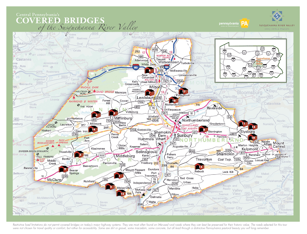
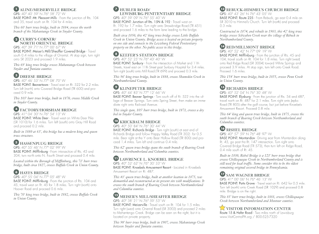
A Driving Tour Route of 15 Covered Bridges.
This is from a 1978 article in the Lancaster Sunday News. I've included the text below, adding recent photos of the bridges and links to more information on each of them. I was unable to find much about the actual event in 1978. Although the article mentions 19 standing bridges in 3 counties, it appears to only list 15, and one of those is in a 4th county - Clinton. Although I have not taken this exact route, I live in middle of the northern end of the route, these are bridges I have visited frequently over the years.
"Fall foliage and covered bridges-its a combination that's hard to resist, even if it means a fairly long Sunday drive. Just such a combination is being offered in mid-October when the tourist promotion agencies of Northumberland, Snyder and Union counties will sponsor the Central Susquehanna Valley Covered Bridge Days. Full details on the drive-it-yourself covered bridge tour are available by writing to the Central Susquehanna Valley Covered Bridge Assn., Hotel Edison, 401 Market St., Sunbury, Pa. 17801. They have a brochure picturing all of the bridges and containing a map of the tour route.
There are 19 covered bridges still standing in the three-county area, with 18 viewable from public roads. One is on private property. Although some special events are being planned for Covered Bridge Days, it is possible to make the tour at any convenient time. Plan for an early start and a long day, however, because seeing all of the 18 accessible bridges means a journey of several hundred miles from Lancaster. Depending upon your choice, it is possible to pick up the tour route off of Routes 11-15 midway between Clark's Ferry and Selinsgrove, or via Routes 54 and 487 at Elysburg.
Continue another half-mile to LR 34012 and turn right to reach the Beaver covered bridge.
From there it's backtrack to Route 104 and head north to the Aline covered bridge on that road.
Continuing along Route 104 will bring you to Middleburg and Route 522. Follow Route 522 west for six miles from Middleburg to Township Road 600, turn right and the Dreese covered bridge is a mile ahead.
Backtrack to Rt. 522 and head west again past the village of Beaver Springs to LR 54024, turn right for six-tenths of a mile and then right again on Township Road 574 to the Klinepeter covered bridge.
From there its back to Beaver Springs and north on Route 235 to the village of Glen Iron, turning right on LR 59005 which brings you to the Red covered bridge, a 151-foot Burr truss bridge built in 1855.
Continue into the village of Millmont and follow LR 59006 north to its intersection with Route 45. HEAD EAST ON that route to Township Road 376 which goes left about two miles west of Mifflinburg. The township route leads to the Hayes covered bridge, built in 1882. Backtrack to Route 45 and head east again to its intersection with Route 304 in Mifflinburg.
A left turn onto Fourth Street will take you to the Hassenplug bridge within the town limits. Built in 1827, it crosses Buffalo Creek.
Back to Route 45 and follow a local road left to Forest Hill and an intersection with Route 192. Follow that road westward to an intersection with Route 477 at Livonia. A short drive north on that route will bring you to LR 18046, and a left to the village of Greenburr. About a mile west of Greenburr, LR 18026 goes right to the Logan Mill covered bridge.
From there, its back to Route 477 and north to the interchange with Interstate 80. Although the brochure map traverses local routes eastward from Logan-ton, we'd recommend taking the interstate since there are no more bridges to be viewed until the village of White Deer. LEAVE THE INTERSTATE at the Route 15 interchange and go north to White Deer, turning west on White Deer Pike 1.6 miles to Township Road 516. A left there brings you to the Factory covered bridge over White Deer Creek.
Returning to Route 15, follow it south to Lewisburg and Route 45 once again. Take Route 45 left across the West Branch of the Susquehanna, through the village of Montandon to Township Road 574 less than a mile east of Montandon. A right turn will bring you to the Rishel covered bridge, built in 1812 and [ it was later discovered that the 1812 bridge had been destroyed in a flood, it was rebuilt at a later date] believed to be the oldest covered bridge in the nation. It is a 94-foot Burr truss bridge spanning Chil-lisquaque Creek. Return to Route 45 and continue east a short distance where a township road bears left to Pottsgrove and Route 642.
A half-mile east of Pottsgrove, LR 49057 goes left to the 78-foot Sam Wagner bridge built about 1812.
Continue to LR 47003 and follow it to Township Road 436 where a right tum brings you to Keefers covered bridge. Then follow LR 47003 to its junction with Route 254 and a right tum to Washingtonville. There pick up Route 54 in Washingtonville and head south to Danville. AT THIS POINT it is possible to shorten the torn- if you don't mind skipping the Keefer's Station covered bridge outside Sunbury and the Rebuck bridge further south.
For those who want to see all of the bridges, turn west on Route 11 in Danville, follow it to Northumberland and Route 147 left to Market Street in Sunbury. From the intersection of Market and 11th Streets turn east on 11th Street to Township Road 698 about three miles past Sunbury Hospital. A right turn on the township road brings you to the bridge.
To get to the Rebuck Bridge, return to Route 147 in Sunbury and follow it south along the Susquehanna to an intersection"
https://www.visitcentralpa.org/things-to-do/history-and-heritage/covered-bridges/
READ MORE
===============

.jpg)
.jpg)
.jpg)


.jpg)


.jpg)


No comments:
Post a Comment
I'll read the comments and approve them to post as soon as I can! Thanks for stopping by!